Greyfriars Development Brief SPD
3 Site Appraisal and development influences
Comprehensive analysis of the SPD area and wider context has been undertaken to inform the development drivers and acknowledging the site constraints. This section collates the site analysis carried out, drawing from various external references including surveys and evidence base documents where relevant.

3.1 Context
3.1.1 Bedford is the largest settlement in the Borough of Bedford, and the second largest settlement in Bedfordshire, after Luton. Bedford Borough saw a population increase of 17.7% (from 157,500 to 185,300) between 2011 and 2021, which is the highest population increase in the East of England (which saw an average increase of 8.3%)(ONS, 2022[1]).
3.1.2 The market town is located between the other notable settlements of Kempston, Milton Keynes, Cambridge, and Luton. Conveniently located between the A1 motorway and M1 motorway, the town is also well connected via Bedford Railway Station, which sits on the main line from London St Pancras to the East Midlands. The town has a historic core, which is focussed around the High Street, on the northern side of the River Great Ouse. Other notable features include Bedford Park, Bedford Prison, and the Castle Mound.
3.1.3 More widely across the town, Bedford is forecast to undergo significant population growth, and there is demand for new infrastructure projects and redevelopment opportunities. Other regeneration projects have been identified, including work around the existing railway station, upgrades to Midland Road, and redevelopment of the (southern) Greyfriars site. When the East West Rail project is realised, Bedford will get a new direct link to Cambridge and Oxford, and passenger numbers are likely to increase significantly. Masterplans for Bedford Town Centre were produced as part of the One Public Estate programme, which is set to deliver an ambitious series of works focussed on publicly owned assets to regenerate the town centre. The completion of the Riverside Bedford scheme has produced a new mixed use development that has successfully increased footfall through the centre.

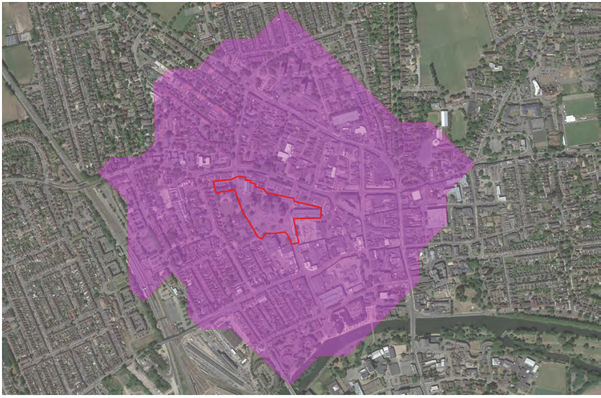
3.2 SPD Area Location
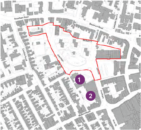
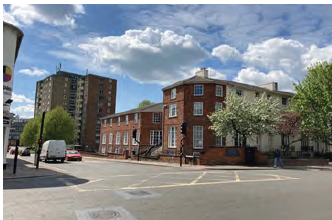
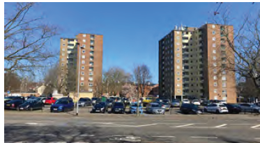
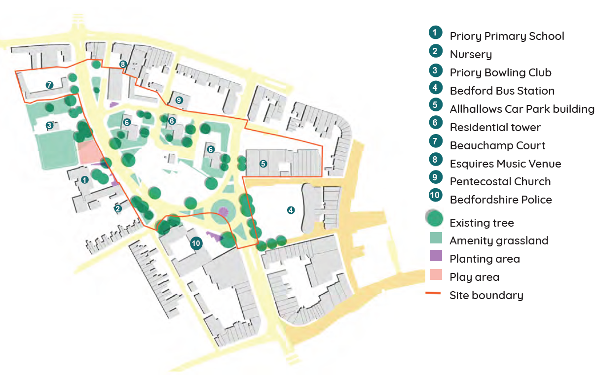
3.2.1 The SPD area is situated on the fringes and to the west of the town centre of Bedford. It is bounded by Bromham Road and Beckett Street to the north; Greyfriars to the east (including the bus station and shops on Greyfriars); and Greyfriars, the road to the west (which wraps the SPD area on two sides). The SPD area focusses on land to the north of the existing roundabout, which is occupied by three residential blocks and a large surface car park. The residential blocks are the tallest buildings (approximately 12 storeys) in the immediate area, and are surrounded by open space. The SPD area also covers Beauchamp court (a six-storey linear apartment block) to the west, and the Allhallows Multistorey Car Park which fronts Bedford Bus Station.
3.3 Surrounding Development Proposals
3.3.1 The Bedford Central Town Masterplan identifies strategic long-term opportunities for development, as well as shorter term interventions to public realm, along Midland Road for example. There are medium to long-term plans to redevelop Bedford Railway Station, which would enhance connectivity to and from Bedford, making the links between the town centre and the station even more important.
3.3.2 Elements of the town centre masterplan which are relevant to the Greyfriars SPD area, and how the Greyfriars SPD area relates to these:
- Identification of signalised junction improvements at the existing Greyfriars roundabout. This piece of work is currently in the pipeline, and will be delivered by the Highways Authority, dramatically improving pedestrian safety, congestion, and the public realm around the bus station, SPD area, and the police station.
- Reduce the width of Midland Road and improve the public realm in order to make this a better pedestrian environment and improve access towards the railway station. Although there is less of a direct link to the SPD area, enhanced access to the station and town centre, and better pedestrian environments will also benefit the Greyfriars SPD area.
- The masterplan recommends heights of 2-8 storeys on the police station and adjacent site, with the taller elements suitable to the north on the police station site, lowering to 2 storeys to the respond to the residential nature of Priory Street. The proposed heights in this masterplan have informed the heights of the buildings proposed on the Greyfriars SPD area, demonstrating an transition in building height and density to signify a town centre location and "landmark" elements.
3.3.3 There are several significant developments taking place on specific sites across Bedford, and there are two proposals for schemes in very close proximity to the SPD area which could have an impact on the character of this and the wider area.
- Greyfriars Police Station. An outline application (ref. 20/00140/MAO) has received a resolution to grant by BBC for the demolition of the vacant police station opposite the SPD area, and the construction of 105 residential dwellings, the realignment of the junction, and car parking. Though the application is at outline stage only, the parameters indicate a massing and height of between 2 and 9 storeys, peaking at the north eastern edge of the site on the new signalised junction, and stepping down towards Priory Street. This, the applicant argues, is to reflect the transition between the 'urbanised' character of Greyfriars and the 'domestic' character of Priory Street.
- Castle Cap Scheme. There is also early conceptual work being undertaken on the site immediately south of the police station site, which is currently occupied by a three-storey retail parade along Greyfriars road, and turning the corner onto Midland Road. Early proposals suggest comprehensive redevelopment of the site to provide Build to Rent accommodation and commercial uses within a high-density development.
Location of surrounding development proposals
3.3.4 These two proposals in immediate proximity to the SPD area suggest future regeneration of the area, which will provide new urban accommodation across Bedford town centre. The redevelopment of the SPD area, alongside these two proposals, is likely to change the character of this edge of town centre location.

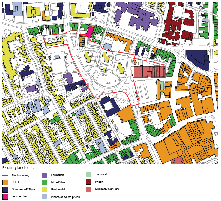
3.4.1 Bedford town centre has a wide range of employment, leisure, retail and cultural assets, and there is further change expected. Redevelopment opportunities have been focussed on brownfield sites in the town centre, in part through the One Public Estates Programme. BBC have an aspiration to introduce more town centre living, and enhance the visitor experience in the town.
3.4.2 The SPD area is on the fringe of the town centre, and therefore hosts a variety of uses, although the predominant use is residential. The eastern boundary marks the transition into the town centre, and alongside the bus station, is categorised by traditional high street uses including retail, office and commercial spaces. Similarly Midland Road is identified as a local centre with a number of retail and community uses, although there is also a large area of predominantly terraced housing. To the west of the site is further residential terraced housing, as well as the main railway station. North of the site is categorised by more historic residential uses, including the majority of the heritage assets in, and nearby, the SPD area. The residential character is punctuated by a series of institutional buildings including the Bedford Sixth Form College, Bedford Prison, and the former St Etheldreda's Children's Home.
3.4.3 The SPD area therefore benefits from being in close proximity to a wide variety of land uses, with town centre activities within 5 minutes' walk from the site.
3.4.4 The commercial floorspace currently on North Parade will be re-provided within the SPD area, and the Council will retain ownership of the new commercial units

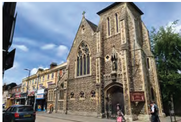
3.5.1 There are no dedicated community facilities within the SPD Area. However, within very close proximity there are several places of worship, including Bedford Pentecostal Church, which abuts the northern boundary of the area. There are also several places of worship to the west of the SPD area, which serve the immediate residential population, as well as residents from wider Bedford.
3.5.2 Priory Primary School sits at the western edge of the SPD area, which is a small primary school serving the surrounding community. Bedford Sixth Form College is situated to the north of the SPD area, and is a highly regarded private school, attracting students from the town and wider catchment area. The Girls' School also now has use of the Church of the Holy Trinity, which was a formerly listed building, but is now used as part of the school's kitchens and dining rooms.
3.5.3 Whilst not meeting the traditional definition of a 'community facility', Esquires Music Venue is a widely- known and much-respected independent music venue which has been an important local asset for over 30 years. Having hosted some of the UK's biggest artists, the venue was financially supported by a successful crowdfunding campaign when it was forced to close during the COVID-19 lockdowns in 2020.
3.6 Tenures/ownership
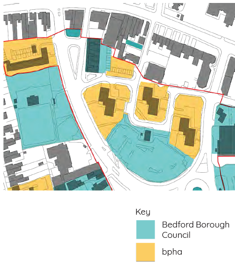
3.6.1 The SPD area has mixed ownership, which is split between Bedford Borough Council, and hhhbpha. bpha are a housing association, who own and manage the existing residential accommodation on site (including Beauchamp Court, Roise Court, Priory Court, and Beckett Court, but excluding the North Parade shops which is owned by the Council). Some of the homes have been bought, but the majority remain within the ownership of bpha.
3.7 Building heights
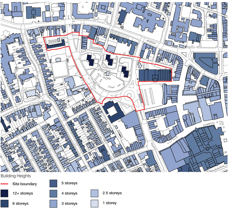
3.7.1 Bedford is a relatively low-lying town, and most buildings do not exceed 3-4 storeys. Exceptions to this are found in the town centre, along Midland Road, and more widely fronting the river, where new recent development has been constructed with heights between 6-9 storeys. BBC are looking to focus new tall buildings in the town centre, and class tall buildings (depending on the context), as those which 'break the skyline' and are significantly taller than the prevailing heights of buildings in the area.
3.7.2 Draft Policy DM12 in the emerging Local Plan covers Tall Buildings, and states that these must be located in the urban area. These considerations have informed the broad location of tall buildings on the site. Detailed design principles are set out in section 5.
3.7.3 The three existing residential blocks in the SPD area (Roise Court, Priory Court, and Beckett Court) are all 12 storeys, and therefore some of the tallest buildings in the town. The blocks are visible from other parts of the town, including south of the river, and hold an important role as landmarks for wayfinding. The SPD area also hosts other taller elements within the boundary, or immediately adjacent, including: Beauchamp Court (6 storeys); Allhallows Car Park (5 storeys); and the former Police Station (6 storeys).
3.8.1 The market town has an extensive history, and archaeological evidence suggests it is one of the earliest Saxon towns in the country. Set on the banks of the River Great Ouse, the settlement was initially established around a ford across the river, and became an important trading centre for the nearby hinterland. The town remained a modest, self-contained, settlement until the end of C18, which saw increased industry and manufacturing processes lead to population growth. The arrival of the railway in C19 accelerated the growth, and the town expanded north west, resulting in suburban terraced streets and new estates for the middle classes and workers housing. First development of the SPD area was terraced housing on the outskirts of the town centre. This housing was demolished in the 1950s, and the road re-aligned to install the Greyfriars roundabout and 5 new residential blocks (3 of which survive on the site today). In the early 2000s, as part of a wider plan for regeneration, two of the original blocks were demolished in anticipation of this redevelopment, however when the original plan stalled, the southern half of the SPD area was turned into a temporary surface car park.
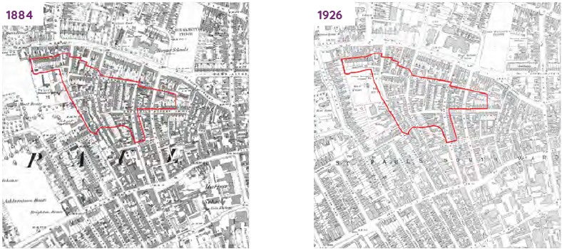
1884: The Greyfriars SPD area is a densely built-up area
with a close-grained network of residential streets
tightly defined by buildings. It is sited on the west edge
of Bedford. It lies south of an area of more generous
Georgian terraces on Bromham Road and northwest
of larger-scaled buildings with more generous
forecourts associated with Harpur Schools around
Midland Road.
1926: Relatively little change to the
Greyfriars area or to its context
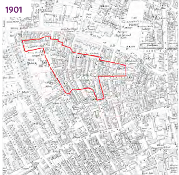
1901:The Greyfriars area is largely unchanged. An
area of more generous residential development
now extends to the west of Greyfriars. The grain of
development around Midland Road has started to
increase.
1967-68: Post-WW2, the Greyfriars area has been
redeveloped .and the historic street network has been
replaced with a pattern of roads designed primarily
to accommodate vehicles. Bromham Road has lost
the tight network of streets with dense built form of its
historic context. The east-west alignment of Beckett
Street is still just discernible immediately to the south,
although with no buildings defining it, while the northsouth
streets have either been subsumed into larger
roads or truncated either by new buildings or open
space
3.8.2 BBC's Heritage Appraisal of the site, which was undertaken to determine the archaeological and heritage features within the SPD area, and any impacts that future development may have on these. The report confirms that:
The Conservation Area derives its distinctiveness from (inter alia):
- The survival of the medieval street pattern.
- Its long term civic and educational role and the associated range of historic buildings and spaces.
- Building and tree framed views.
- The consistent quality of its Georgian and
- Victorian architecture and the presence of mature public space and tree planting.
‘The [SPD] site currently makes a negative contribution to the experience of the Conservation Area and the listed Buildings, though the effect is small’.
‘It is suggested that any new tall structures should maintain a similar distance from 22-48 Bromham Road. Smaller structures of 2-3.5 storeys could be built on the land between 22-48 Bromham Road and the 12-storey towers without having a significant impact on the Listed Buildings, if designed sensitively.’
The report identifies that the areas of particular note in the Conservation Area are situated away from the SPD area and they pose no potential for the proposed development to impact them. The marginal negative impact on the Conservation Area arises from the visibility of the residential blocks (seen from the side streets of Bromham Road) and through the loss of the historic street pattern and urban form of Beckett Street and former north-south streets.
The impacts are mitigated by the distance between the existing blocks and the Conservation Area and its individual heritage assets, and by the gaps or spaces between tall buildings.
3.8.3 Heritage analysis supporting this Development Brief has also highlighted likely impacts that the masterplan may have on surrounding heritage assets.
Potential for increased harm:
- Height of proposed tall buildings were to be increased or proposed tall buildings were to become more prominent in views 1,2 or 3; or
- Proposed tall buildings were to be sited closer to heritage assets.
However, neither of these outcomes is the case for the masterplan as building heights have been reduced and tall buildings are located further away from heritage assets.
Potential for enhancement:
- Height or prominence of proposed tall buildings were to be reduced in views 1,2 or 3; or
- Appearance of existing or proposed buildings were to be better quality and/or more contextually designed in terms of form, massing, scale, materials etc;
- North-south streets running from Bromham Road into SPD area were reconnected;
- Tall buildings set further away from heritage assets; and
- Beckett Street were to be re-defined as an attractive urban street.
These potential enhancements have influenced the masterplan and accommodated within it.
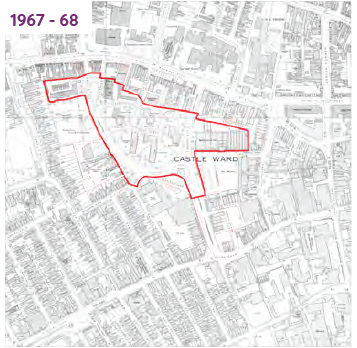
Heritage views
3.8.4 Several important views have been identified as a result of the heritage assessment, which have been considered with regard to the scale, massing and materiality of the future development in the SPD area.
The views identified below must be tested and explored in any future planning application.
View 1: Listed buildings on Bromham Road looking south from The Crescent
View 2: Listed buildings nos 2 to 14 The Crescent
View 3: Listed building viewed from the intersection of Bromham Road and Hassett Street
3.9 Character Analysis
3.9.1 The SPD area sits at an intersection between townscape areas with varying characteristics. The design proposal therefore acknowledges its position at this junction, referencing these important townscape areas and sympathetically responding to them. These areas have been identified based on similar townscape features, including, but not limited to: building typology; street structure; plot size; building line; vernacular, boundary treatments; and landscaping.
3.9.2 The five townscape character areas are:
- Historic Quarter
- Town Centre
- Mixed Residential
- Midland Road Neighbourhood (and Midland Road)
- Riverside

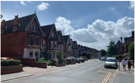
Historic Quarter
This area is predominantly covered by Bedford Conservation Area (CA), which is characterised by:
- The historic fabric of this area being well- preserved in many areas (see The Crescent, Adelaide Square). However modern interventions have also detracted from this coherent character (see modern additions to Bromham Road);
- The character of this area being dominated by the historic street pattern, consistent building frontages, large plots, and prominent landscaping boundary treatments and mature street trees; and
- There is a strong visual connection between this area and the SPD area, and important local wider townscape views.
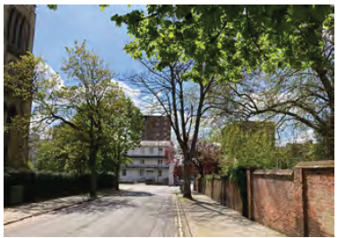
View looking south to the SPD area from The Crescent
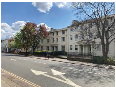
Group of listed buildings with prominent frontage onto Bromham Road.
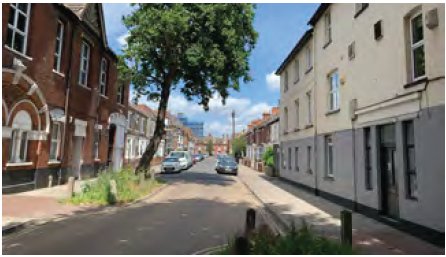
Town Centre
The town centre abuts the eastern edge of the site, and marks a shift in land uses to retail, commercial and civic facilities. This area is characterised by:
- A range of building typologies and architectural styles, including modern development (such as the retail stores along Midland Road, Allhallows car park, and the bus station) as well as the more historic core to the east of Harpur Street;
- Important townscape views on approach to the site looking north from River Street. Beckett Court is highly visible from this approach and dominates the view northwards; and
- A more informal street layout, borne out of the historic urban fabric of Bedford as a market town. This has resulted in varied building frontages and building lines, with little consistency between neighbouring streets.
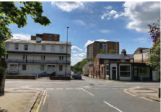
View looking north to the SPD area from the junction at Greyfriars and Midland Road
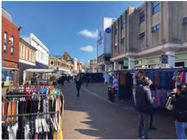
Varied building typologies on the pedestrianised section of Midland Road
Mixed Residential
This area covers land to the west of the site, mostly residential in nature, it includes buildings fronting Ashburnham Road, and notably Bedford Railway Station. This area is characterised by:
- Varied building typologies; including modern apartments, and more historic C19 detached housing. Building heights are predominantly 2-3 storeys, with some newer development of 4-5 storeys - the tallest building in this area is Ashburnham Court, sitting at six storeys on the corner of Ashburnham Road and Woburn Road;
- A range of building footprints and sizes, and an inconsistent building line across much of the area; and
- Woburn Road towards the site, looking eastwards. The residential blocks on the Greyfriars site are visible above the terraced housing on Alexandra Road.
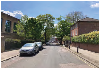
Modern infill development on Conduit Road
Consistent residential typology and strong building line on Conduit Road.
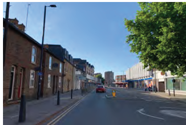
Midland Road Neighbourhood
Midland Road provides a key east-west spine through the area, before entering the threshold to the western town centre boundary at the junction with Greyfriars. This route provides a key linkage from the railway station through the town centre, and acts as a local centre for the residential neighbourhoods immediately north and south of Midland Road. Important features of the residential area include:
- Consistent street structure, plot widths, and building lines;
- Consistent terraced typology and boundary treatments;
- Mostly on-street parking and traffic calming measures;
- Some street planting, including mature trees;
- Consistent building heights – predominantly 2.5 storeys, some with attic conversions and dormer extensions; and
- Predominantly residential uses.
Formal residential layout (and traffic calming measures) on Grafton Road
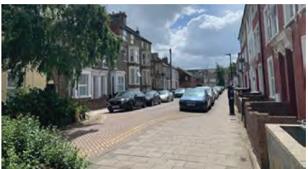
Strong building frontage onto road with minimal setback, and some street planting (Western Street).
Midland Road itself is different in character.
Characteristics include:
- A busy, linear, local centre primarily serving the immediate surrounding residential community as well as a focal point for fast-food outlets;
- A range of high street uses and non-residential uses, including churches, restaurants and leisure facilities. Midland Road is distinguished from the 'town centre' of Bedford by its retail offering (small independent shops), and building typologies (a range of C19 architecture, as well
- Mixed building heights and typologies. Predominantly 2-3 storeys in height, with a range of C19 terraced buildings, mixed with gable ends, and town-houses;
- Inconsistent building line and frontages to the street. Some original shops front the street directly, whilst some residential dwellings are set back from the street with small front gardens; and
- Its function as a key pedestrian (and vehicular) route from railway station through to the town centre.
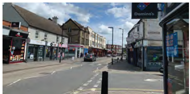
Important pedestrian linkage through to the town centre
Varied land uses and local community facilities on Midland Road
Riverside
The River Great Ouse is the most prominent natural feature in Bedford, flowing east-west through the town. The area fronting the river to the north has been identified as having distinctive character, albeit not in direct proximity to the site. Direct visual connections between this area and the existing residential blocks which can be viewed up River Street make this a relevant consideration. Key features include:
- Range of building typologies, including large multi- storey modern mixed-use developments, and also historical buildings (for example Bedford County Court); and
- Six-storey development at River's edge.
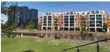
Modern mixed use development at the river's edge
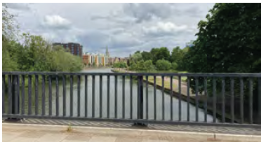
View from Country Bridge looking over the River Great Ouse towards the new mixed use development
View looking north to the SPD area from River Street
3.10 Landscape, Ecology and biodiversity
3.10.1 Bedford Borough is characterised by gently undulating topography, which has been used as an intensive arable landscape for centuries. Bedford's historical role as an agricultural market town has meant the landscape has always held an important role in Bedford's prominence as a town. To the south of Bedford town is the Forest of Marston Vale, which is a 61 sq. mile community forest, designated as a national priority area for environmentally-led regeneration of degraded and industrially scarred landscapes. Bedford Borough Council published their Green Infrastructure Plan in 2009, which outlines strategies to link and enhance the existing green infrastructure assets across the Borough, including Upper and Lower Great Ouse River Valley (including where the river runs through the town). The Plan outlines measures to enhance connections and access to the nearby countryside, as the immediate town centre itself does not have an abundance of readily accessible green open space. Bedford Park, Russell Park, and the River are all located within 20 minutes walk of the SPD area.
3.10.2 There are no statutory or non-statutory designated sites in the Greyfriars SPD area. The nearest statutory site is the Hill Rise Local Nature Reserve located approximately 905m north of the site. The nearest non-statutory site is the River Great Ouse County Wildlife Site, approximately 225m south of the site. Due to the distance, and lack of connectivity to these designated sites, the potential for impacts is considered low.
3.10.3 The Priory Recreation Ground, which abuts the western boundary of the SPD area, is identified as an 'Urban Open Space' in the Allocations and Designations Local Plan 2013. This space has been identified for having a particular importance in maintaining the function, character and identity of the urban area.
3.10.4 Ecological analysis reveals that the dominant habitats within the SPD area include hardstanding and buildings, with discrete areas of amenity grassland, mature trees, hedges and ornamental planting. These habitats in combination were considered to be of low ecological value.
3.10.5 The site overall was considered to have negligible suitability for commuting and/or foraging bats.
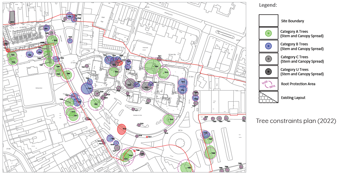
3.10.6 Although Greyfriars is predominantly hard landscaped, a good variety of healthy mature trees are evident across the site. These are clustered around the residential tower blocks and the western and eastern boundaries. This includes several Category A trees, which will be protected where possible.
3.10.7 Areas of amenity grassland with low environmental value are visible through parts of the site, principally around the residential buildings. Localised clusters of ornamental planting can be seen to the front of Priory Primary School and around Greyfriars road.
3.10.8 Overall, the site is dominated by road infrastructure and the surface car parking, however, there are opportunities to improve the quality and quantity of open space on site.
3.11 Public realm and private space
3.11.1 The SPD area is characterised by a combination of public and private spaces, the thresholds and boundaries of which are somewhat unclear. The three residential blocks are situated in open space, and there is a pedestrian footpath intersecting the blocks. Beauchamp Court has a courtyard (used predominantly for parking and servicing) which feels more semiprivate for residents only. There is very little private amenity space for existing residents, though the existing residential blocks mostly have balconies, and some residents of Beauchamp Court have access to ground floor gardens (south side only).
3.11.2 The public open space around the base of the residential blocks is mostly amenity grassland, and poorly utilised. Anecdotally, the green space is often used for antisocial parking, and there are also antisocial behaviour issues that have been reported at the base of the blocks. The lack of space (the grassed areas are relatively small), and proximity to busy roads and car park are most likely the reasons that children do not play in these areas. The playground across the road at Priory Recreation Ground is more frequently used by parents and young children, particularly after school hours.
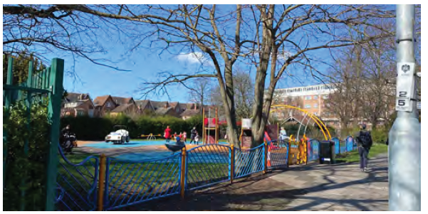
Priory recreation ground
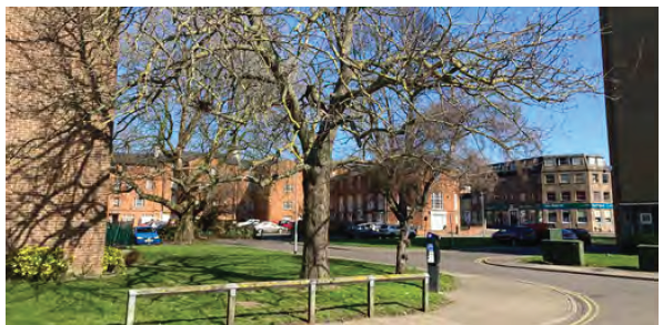
Mature trees amongst existing residential blocks
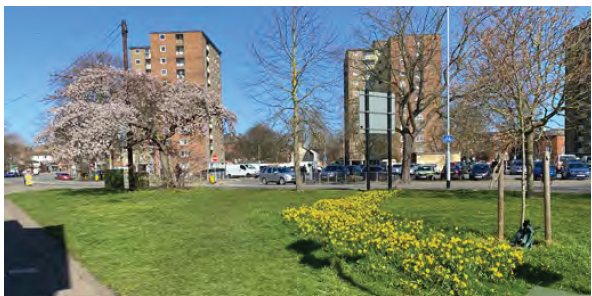
Planting and low-level vegetation
3.12 Utilities
3.12.1 There are several utilities connections across, and underneath the SPD area. Most notably, there is an electricity substation on the site, which is currently located on the surface car park. A concentration of underground utility services can be found running east-west across the site. These are predominantly serving the existing tower blocks and form a considerable underground constraint for phased development. The sub-station requires 24-hour vehicle access.
3.13 Flooding
3.13.1 The development must be supported by a site specific flood risk assessment (SSFRA) to address all potential flood risks to the site and the risks can be summarised as follows.
3.13.2 The Environment Agency Flood Maps for Planning (River and Sea) indicate that the majority of the site is in Flood Zone 1 (Low Risk) with a 0.1% chance of flooding from rivers (fluvial flooding) in any given year. However, there is a small area in the south of the site which is classified as Flood Zone 2 (Medium Risk) with a chance of fluvial flooding between 1% and 0.1%.
3.13.3 Current surface water flood mapping shows that flooding is predicted to occur within the site along the route of Beckett Street during both the 1 in 30 and 1 in 100 year storm events but it is not shown to extend beyond the site boundary indicating that the source of the flooding is within the site itself. There is also predicted to be surface water flooding within Greyfriars Road along the south-western boundary of the site and within the roundabout at the junction with Hassett Street. The re-development of the site will involve the re-configuration of the site and the corresponding replacement of the surface water sewer system. As part of these works, the surface water run-off from the site will be attenuated to green field run-off rates thereby reducing the peak flows to the sewer system and any residual capacity issues will be addressed by on-site sewer replacement/ upgrades. Independent of the SPD development area, the Greyfriars Road/ Hassett Street junction is to be subject to reconfiguration and this will involve corresponding alteration of the sewer system as part of which local capacity issues should be addressed.
3.13.4 The site is accessible from the south via Greyfriars Road and also from the north via Roise Street and Hassett Street/ Beckett Street. Both these northern routes are unaffected by either fluvial flooding or surface water flooding and, hence, in the event that surface water flooding were to occur within Greyfriars Road and/ or the Greyfriars Road/ Hassett Street junction, two locations with safe access and egress to/ from the site will remain.
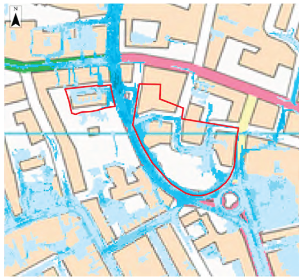
Map showing surface water run off
Bedford Borough Council Level 2 Strategic Flood Risk Assessment
3.14 Access and connectivity
3.14.1 Greyfriars road forms a key part of the town centre vehicle movement network, accommodating two-way traffic travelling north and south. As High Street only permits southbound movement, Greyfriars road is particularly important for northbound traffic. Greyfriars road then connects to Bromham Road (A4280), which is the largest east-west connector route across the town. Bedford Sixth Form College, Priory Primary School, Greyfriars surface car park, and Bedford Bus Station all result in a high number of vehicle movements and a very busy road network around the SPD area. The highway infrastructure currently prioritises vehicle movement over the movement of people to and from the town centre (although improved pedestrian crossings have been installed in recent years and a new junction to replace the roundabout will help active travel connectivity further).
3.14.2 There are numerous vehicle access points for service areas and parking, and which leads to convoluted road design, and excessive hardstanding.
3.14.3 The north side of Beckett Street is fronted by a number of 'backs' of buildings which front onto Bromham Road. Car parks, service areas, and garages all create inactive semi-private edges to this street, creating an unsuccessful and illegible pedestrian environment.
3.14.4 Cycle routes, and cycle infrastructure across the town is disconnected. Cycle infrastructure includes a mixture of on-road cycling, shared pathways, and bus lanes. There is a lack of formal separation for cyclists, both at junctions, and on the carriageway (though there are two bike shops within the SPD area).
3.14.5 The railway station and town centre are within 10-minutes walking distance of the SPD area. However, pedestrian permeability and legibility from the station, across the SPD area and to the town centre are not very clear. There are clear opportunities to improve existing connections, by installing new crossing points, particularly to serve Priory Primary School, the town centre, and the route through to the railway station.
3.14.6 The site is extremely well located, in immediate proximity to Bedford town centre and the bus station, and within a 10-minute walk to the railway station. The location has very high access to public transport, town centre services and amenities and local employment opportunities. This provides an opportunity to create a place focussed around walking, cycling, public transport use and public life.
3.14.7 Greyfriars and Hassett Street are key streets passing through the site. Planned changes to the street network include the Greyfriars/Hassett Street junction, which will be transformed from a large unsignalised roundabout, to a more space-efficient signalised T-junction with new formal crossing points for people walking, and segregated cycle facilities. Hassett Street and Greyfriars (south of the junction) will also be upgraded to provide new segregated cycle tracks.
3.14.8 Greyfriars (north) is currently wider than necessary, lacks formal crossing points and good quality footways and cycle infrastructure. The area around Priory Primary School is particularly important to improve for children. There is an opportunity to upgrade Greyfriars to better tie in with the walking and cycling network, and proposals for Hassett Street.
3.14.9 Alexandra Place is a local residential street, however exhibits high levels of rat-running traffic during peak times. Similarly, Gwyn Street and Brace Street provide a rat-run for drivers seeking to avoid the signalised junction at Hassett Street/Bromham Road.
3.14.10 BBC have identified that a 'business as usual' approach is not going to deliver sustainable growth, and therefore their transport strategy will: support the delivery of low carbon transport; promote connectivity and accessibility in new development, linking to existing communities; and support opportunities for active travel and green infrastructure. The Council have already taken the first step to develop design proposals that will transform the roundabout junction at Greyfriars/Hassett Street into a more space- efficient signalised T-junction with segregated cycle facilities, helping to encourage sustainable travel and reduce the dominance of the junction, and unlock development opportunities.. There is an opportunity to extend this to the north along Greyfriars road. (Note all proposals plans within this document show the new committed junction arrangement.)
3.15 Parking
3.15.1 There are numerous parking options for visitors arriving in Bedford by car. Within proximity of the SPD area, there are eight car parks resulting an abundance of parking options, and as the parking survey data outlines, are rarely fully utilised. Weekday utilisation across all car parks combined was just 42%, but there were significant variations in usage between different locations. Allhallows car park (428 spaces) measured just 17% utilisation, whereas Bedford station measured 89% utilisation, when spot checks were undertaken mid-week. Greyfriars surface car park (143 spaces) measured 49% utilisation.
3.15.2 Within the SPD area, there are 53 on-street parking spaces, which are either for use of residents, or pay-and-display. Across the SPD area as a whole, daytime utilisation was surveyed to be 72%, which could be expected to be higher in the evening/overnight. There is also a degree of private non- residential parking that takes place (usually in an ad- hoc manner), associated with deliveries/servicing.
3.15.3 Therefore, there are clearly opportunities to rationalise the parking options within the SPD area.There are also plans to upgrade the MSCP with improved lighting/entranceway to make this a more convenient and attractive parking option.
3.15.4 It is assumed that going forward the site itself will be car-free, apart from blue-badge parking. Existing residents' spaces will be reprovided within the MSCP.
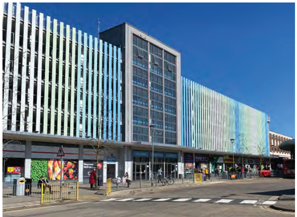
Allhallows MSCP
3.16 Summary of site Constraints
Key constraints include:
- Electricity substation on Greyfriars surface car park, and the requirement to retain this in-situ;
- Direct and indirect impact on the Bedford Conservation Area and subsequent restrictions on height of development to the northern area of the site;
- Several listed buildings in close proximity to the site (potential impact with regard to setting and views); and
- Several mature (class A) trees on-site.
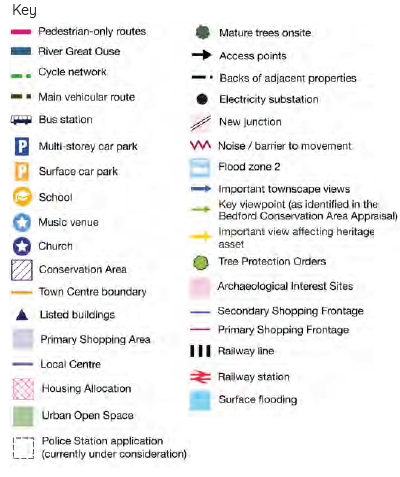
Summary constraints plan
3.17 Summary of site Opportunities
Key opportunities include:
- The gateway opportunity that Greyfriars provides, in its location on the edge of the town centre;
- The opportunity to create active frontages along Greyfriars road, and improve connections/crossings across it;
- Opportunities to rationalise the layout of the site and improve the urban environment;
- Opportunities to improve views and inter-visibility with Bedford Conservation Area (and nearby listed buildings); and
- Opportunities for providing green open space and retaining existing mature trees.
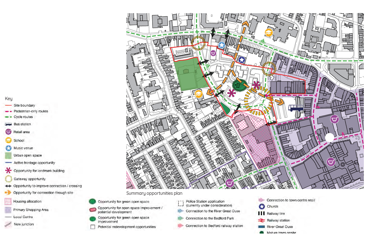
Summary opportunities plan