Greyfriars Development Brief SPD
5 Development Principles

5.1 Development principles
5.1.1 Based on engagement and current policy aspirations, the following principles have guided the development of the Greyfriars masterplan.

Connections and routes.
- Retain permeability across the site, connecting key nodes of activity and respecting existing desire lines;
- Reinstate established and historic north-south, and east-west routes across the site, which make reference to the historic residential street pattern visible in the late C19 and early C20. The north-south route linking The Crescent to Alexandra Place partly follows the route formerly known as Greyfriars Walk, and the route from the bus station east-west into the centre of the site follows the layout of a road once known as Greenhill Street; and
- Retain direct link to the bus station and town centre.
Landscape, character and biodiversity net gain
- Retention of Category A trees where possible.
- Increase the quality, quantum, and usability of open space.

Perimeter block layout
- A range of typologies will be used to create perimeter blocks, which allow for the enclosure and creation of safe communal spaces such as resident courtyards.
- Open space to be robustly defined as private, communal (for residents only) or public with a clear purpose and ownership.
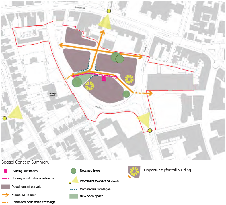
Spatial Concept Summary
5.1.2 Taking influence from the analysis, engagement, and vision, the following section provides a coordinated masterplan for the development of the SPD area. All planning applications and projects are expected to accord with these principles in relation to the following:
- Access and movement principles;
- Land use principles;
- Building heights;
- Character area principles; and
- Open space, landscape and public realm.
5.1.3 The masterplan has been developed through option, capacity studies and associated cost and viability assessments. Below this section sets out the design principles that will guide any future development proposals.
5.1.4 The SPD area is currently occupied by 254 dwellings, and these will be re- provided on-site like- for-like but in accordance with Nationally Described Space Standards (NDSS). The minimum capacity to be achieved is 254 units + uplift of private units to enable redevelopment and creation of mixed community. High-level options and viability assessments have demonstrated a feasible capacity of around 344 homes.
5.1.5 This development brief does not stipulate a maximum or minimum number of homes. The exact number of homes will depend on the phasing and detailed housing mix requirements. The brief, however, sets the maximum height and development envelope in conjunction with a set of design principles and mandatory requirements to ensure the appropriate quality is achieved. Future proposals will be assessed against these principles and the design code in section 6.
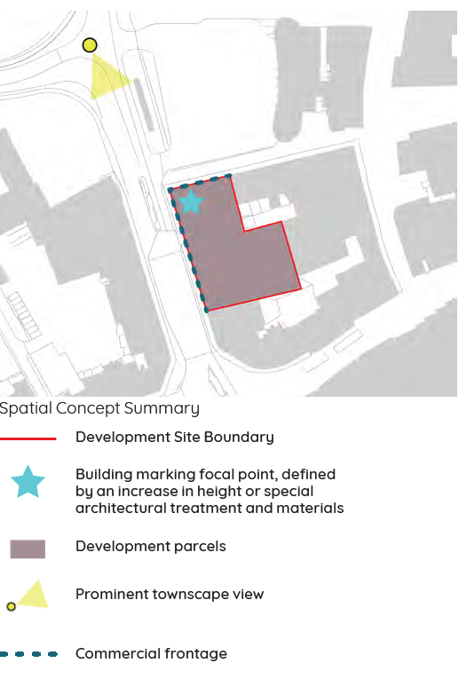
5.1.6 Greyfriars East development principles
Whilst within the SPD area, Greyfriars East has not been developed with the same level of detail as the Greyfriars masterplan. Greyfriars East has much more of a "high street" context compared to the Greyfriars masterplan site, with ground floor shops and bus station activities making it a lively pedestrian route.
The following design principles should be followed when this site comes forward:
- Mixed use development with ground floor active frontage on to Greyfriars road and bus station
- Continuous strong building edge fronting Greyfriars road and the bus station
- Mark the corner with notable articulation, height or material change
- Residential uses are suitable above ground floor
- Contribute to an improved Greyfriars road public realm and street greening

5.2 The illustrative masterplan
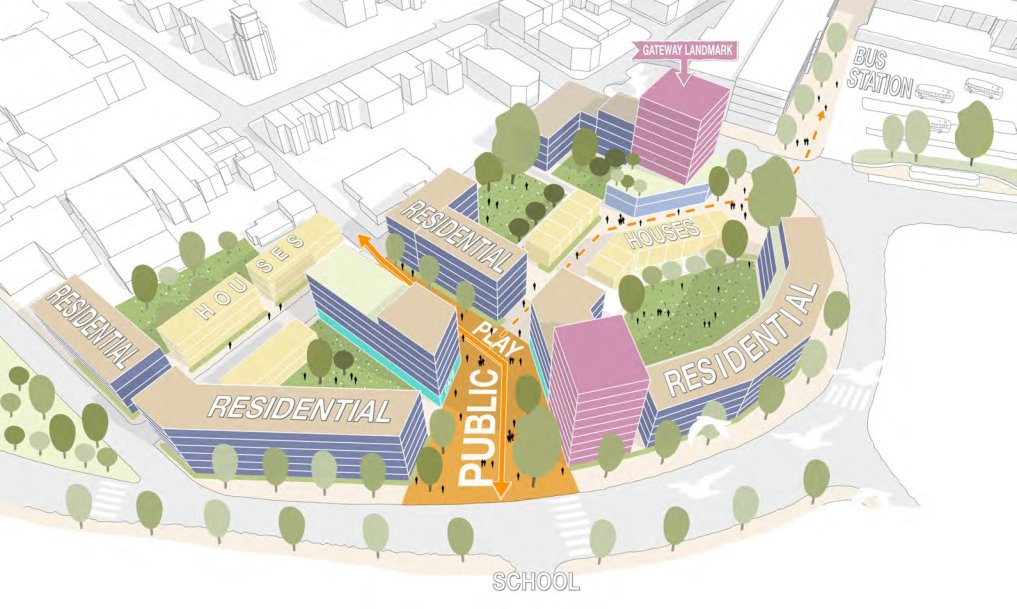
5.2.1 The illustrative masterplan shows one way of how the principles and development requirements could be met.
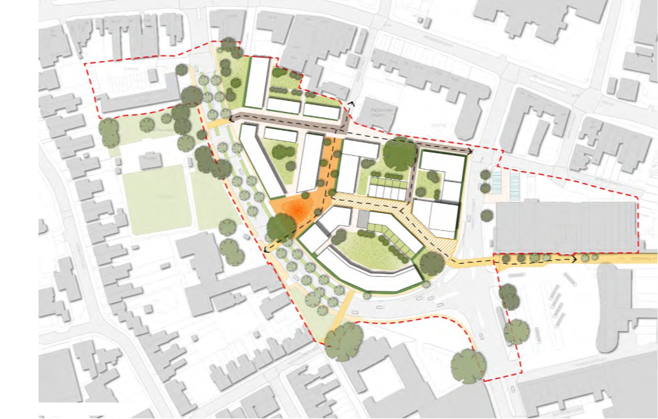
Illustrative masterplan
Illustrative 3D view of masterplan
5.3.1 The priority for the SPD area is the creation of a people-friendly environment. The masterplan has focussed on creating a permeable, legible layout that encourages pedestrian priority across the site.
5.3.2 Manual for Streets (MfS) and Manual for Streets 2 (MfS2) should be used to inform the design of the streets and junctions that comprise the development. Unlike Design Manual for Roads and Bridges (DMRB), which is produced primarily for application to the trunk road network, these documents have been produced specifically for use in urban environments.
5.3.3 Access from Becket Street to the existing properties, car parking areas and service areas outside the site boundary will be retained and accommodated in any future development.
5.3.4 The routes have been informed by the historic north-south, and east-west routes which were once visible in the C19 and early C20 layout of the area. The primary pedestrian routes will therefore route pedestrians from the town centre into the site, and also north-south to Bromham Road and The Crescent. Notwithstanding this, Greyfriars road will also remain an important route of connection, and the street will be enhanced to improve the pedestrian environment with planting, street furniture, and bicycle lanes.
5.3.5 In addition to the planned street improvements at Hassett Street/Greyfriars (southern section), masterplan proposals should include the projects set out below.

Greyfriars 'avenue'
5.3.6 Improvements to Greyfriars (northern section) to create a people-friendly avenue supporting walking, wheeling and cycling, and enhancing biodiversity. Greyfriars improvements will narrow the carriageway, introduce segregated with-flow cycle tracks (tying in with the Greyfriars/Hassett Street junction), widen footways and introduce an avenue of street trees and in-ground planting (such as rain gardens). New crossing points are introduced at Priory Primary School and opposite Beckett Street to align with desire lines through the re-developed area of the masterplan.
Alexandra Place modal filter and pocket park
5.3.7 The Alexandra Place modal filter at the junction with Greyfriars will prevent rat-running and traffic around the junction at peak times, and enhance the safety, comfort and attractiveness of the street environment, particularly for school children and parents. The scheme will also create opportunities for improved public realm such as a pocket park, creating a more attractive, green and biodiverse space supporting the high numbers of people walking and cycling to and from school, the town centre and train station. Vehicle access to Alexandra Place will therefore be from Midland Road and Ashburnham Road.
Gwyn Street modal filter
5.3.8 The introduction of a modal filter at the Gwyn Street/Bromham Road junction will prevent rat-running between Bromham Road and Hassett Street (i.e. drivers seeking to avoid the signalised junction). This could be further enhanced as a public space incorporating greening and links with local businesses.
5.4 Land use principles
5.4.1 The Council's ambition is to regenerate the area as a residential neighbourhood with active edges along the streets and spaces helping to animate the public realm and contribute to the safety and security of the area.
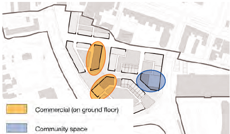
5.4.2 Commercial space: Given the proximity to the town centre, the opportunity for a mix of uses is limited to avoid competing with the town centre. Existing commercial space of around 470sqm will be re- provided within the masterplan but no additional retail or commercial space is permitted. It will be located on the groundfloor of a mixed use building in a prominent and central location.
5.4.3 Community space: In order to enhance the sense of community and activate this new neighbourhood a new community facility is proposed. This will be located at the groundfloor of one of the residential buildings and ideally have access to private open space either in the form of a roof terrace or as part of a communal courtyard.

5.5 Building height strategy
5.5.1 The three existing 12-storey blocks are prominent features within the surrounding townscape area, and are visible from several streets nearby. The scale of the proposed development has been shaped to respond to views from the conservation, potential impact on listed buildings the wider and nearby townscape views, whilst balancing the delivery of new homes. The proposed height strategy includes buildings ranging from 3-9 storeys. In summary:
- The height of development reduces in scale to four storeys along the northern edge to reduce the impact onto the heritage assets and Conservation Area to the north (Location C);
- The main frontage onto Greyfriars is consistent in height and up to 5 storeys. This is balancing the need to respond to the width and importance of this road, terrace development further towards the south-west as well as proposed and emerging developments on the police station site.
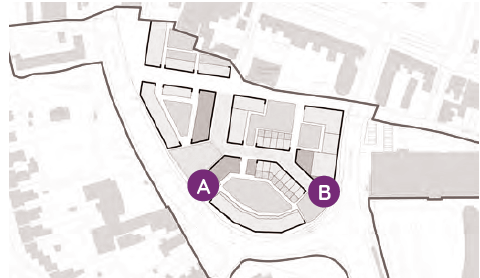
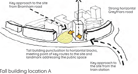
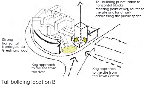
- Two locations are identified for taller buildings up to a maximum of 30m (9 storeys). These are:
- Location A: A taller building in this location marks the arrival to the town centre from the railway station. This is also sufficiently separated from the lower-rise and historic development to the north.
- Location B: At the Greyfriars junction, there is an opportunity to locate a taller building as a landmark, with a long-range visual connection with the Riverfront.
Tall building locations
5.5.2 This strategy has been tested in relation to the heritage views and has been found to improve up on the existing situation and the 12 storey buildings on site.
Existing
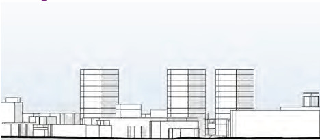
Skyline view from the south towards Greyfriars shows existing 12 storey residential blocks
Proposed
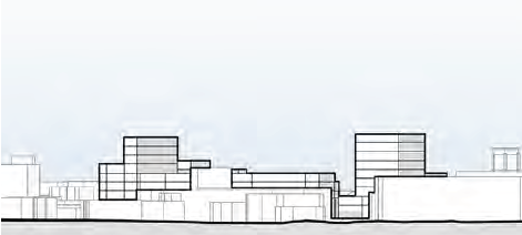
Skyline view of proposed massing showing two landmark
elements

5.6 Character area principles
5.6.1 The masterplan seeks to repair the urban fabric and create a rich urban environment with a mix of building types. It establishes a clear urban pattern of development that integrates the site with the wider area. The urban grain of the proposals reflects the transitional quality of the site, responding to the lower-rise residential area to the west, the tighter grain characterising the town centre as well as the larger development scale of the MSCP, the police station and development along the southern sections of Greyfriars. The urban grain within the SPD area also responds to the context of the site - demonstrating a tighter narrower grain to the northern edge of the site to reflect the historic buildings in the conservation area, and a looser larger grain to the south.
5.6.2 The masterplan sets out a number of character areas, that are related to specific edge conditions, heritage sensitivity and the building types that are expected. As a result a richer character will be created leading to attractive and varied streets and space.
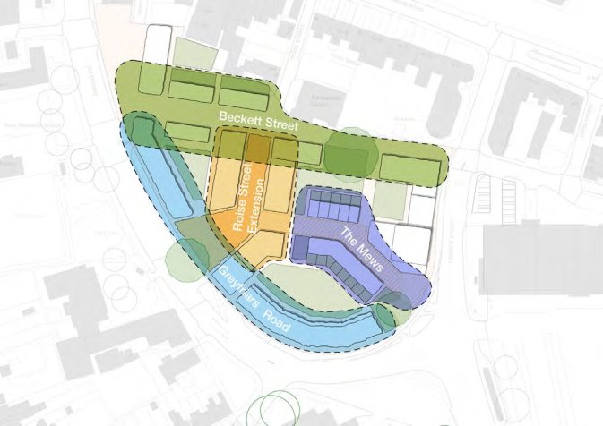
Character area plan
Greyfriars
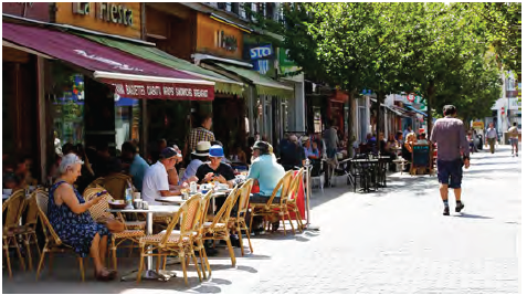
5.6.3 The objective is to transform the character and environment of this road, reducing the dominance of the vehicular traffic and highway, creating a greener, safer environment for people as well as a more positive approach to Bedford town centre. There is a need for a phased and collaborative approach between the developer, the highway authority and the BBC. In order to create the desired frontage and tree planting the existing road space will need to be reallocated. The masterplan proposed to set back the development by 3m from the existing boundary line (back of pavement). Additional space utilised through the reallocation of the road space will enable the desired outcome.
See also section 6.7 for further detail on the Greyfriars road transformation.
5.6.4 The following development principles apply:
- Create a high degree of enclosure with a clearly defined development frontage and long linear blocks along Greyfriars road with a continuous frontage and no breaks.
- Break down linearity and massing of the blocks and consistency in building line and height with a vertical rhythm and articulation to the façade to reflect historic characteristics.
- Create a consistent roofscape. Dormers, terraces and bays windows may break the consistent eves height.
- Upper-storey to have a setback of at least 3m to the rear (inside of the block), to allow improved sunlight/daylight into the courtyard.
- Provide glimpsed views through gateways or entrance halls to the gardens beyond.
- Set back frontages by at least 3 m from edges of kerb line to enable landscape and front gardens to create privacy for groundfloor homes.
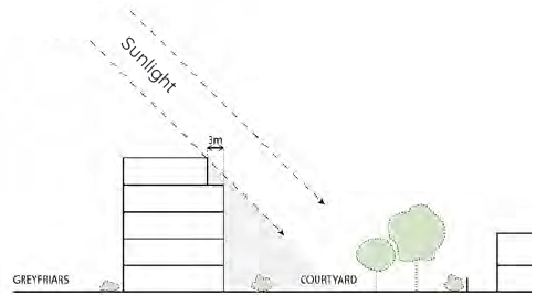
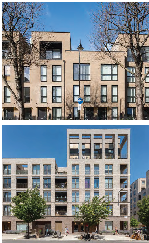
The southern-most linear block, fronting Greyfriars Road, must have an upper storey set back, to allow improved sunlight / daylight into the courtyard
Strong consistent frontage with harmonious roofline, clearly defined and defensible boundaries.
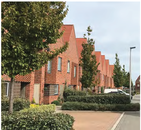
Beckett Street
5.6.5 Development will improve the quality of the route and introduce new frontages responding positively to the existing "backs" of development. The street is to be lined by town houses or maisonettes to create the finer grain and the lower the building height responds to the proximity to the heritage assets and conservation area nearby as well as improves daylight / sunlight levels into Beckett Street, and improves opportunities for eyes in the street (passive surveillance).
The following development principles apply:
- Introduce a "finer" development grain, by using a mixture of house types, predominantly town houses.
- Maximise opportunities for overlooking and activation of this route, through groundfloor entrances and bay windows on ground and upper floors.
- Create a vertical rhythm and each house be clearly distinguishable. Roof and eves heights should be consistent but may be broken by contemporary interpretations of bay windows and gables, taking design inspiration from the Victoria terraces within the surrounding area.
- Vary materials between houses to create a diversity similar to the surrounding Victorian streets.
- Provide private outdoor space, within gardens, patios and/ or upper floor terraces. Upper level terraces can either be accommodated with a set back of the upper level or through the stepping of the roofscape to create terraces in between units.
- Provided front entrances directly onto the street and not through communal courtyards.
- Where garages are integrated on the groundfloor, generous entrance halls with a window must be provided and upper floor windows should be large to secure some element of overlooking.
- Garage must be secured by solid garage doors or grills.
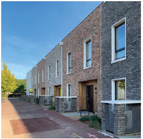
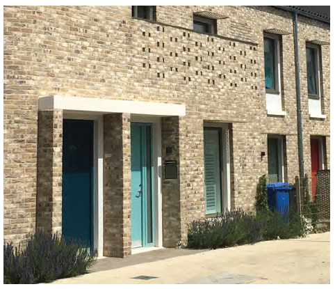
Townhouse typology
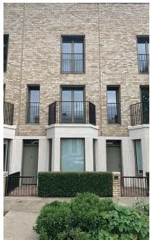
Townhouse typology
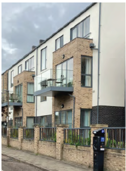
A consistent building line is used to define the street edge on The Avenue.
Roise Street extension
5.6.6 This route will create a new street which aligns partly the historic route once on the site. It will be a pedestrian priority street forming the central point of activity. The following development principles apply:
- Create a public place - the street deliberately widens at this point to mark its importance as a north- south route. The southern extent will be pedestrian and cycle movement only, and the northern extent will be designed to encourage pedestrian priority and allows activities to spill out of commercial groundfloor units.
- The community garden will sit at the intersection of several routes, and will host a variety of functions - including play facilities and an events space - be densely planted, and a convivial public space.
- Create active frontages to define the edges of this space.
- Create commercial frontages of a minimum of 4m floor to ceiling heights on the ground floor of mixed use buildings and allow space for uses to spill out into the public realm.
- Avoid long stretches of monotonous roofscape and reflect the combination of shorter blocks. Variations in building heights and roof shape will enrich the skyline in this central location and allow modelling to ensure good sun- / daylight into the space and communal courtyards. However, this needs to be balanced against sustainability criteria (see section 6).
Varying Heights and Articulated Roof Forms
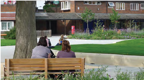
Seating areas facing space
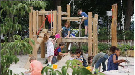
Equipped play space
Active groundfloor
The Mews
5.6.7 This key pedestrian and cycle connection borrows development characteristics from the Victorian Bedford. The lower height of terrace houses provides a change in scale and character. By bringing down the scale of buildings, and bringing homes to the edge of the street, this creates a more intimate pedestrian street. The reduction of building height in the centre of the site also allows more sunlight and daylight into the courtyard to the north.
5.6.8 The following development principles apply:
- Create a intimate street lined with mews housing.
- Ensure views are terminated by buildings creating a sense of enclosure and screening views to the existing MSCP.
- Align the route with the desire line towards the town centre.
- Ensure each frontage has a consistent building line and front garden set back with robust boundary treatments to clearly define private and public space.
- Enable glimpsed views through to landscaped communal courtyards.
- Ensure consistent horizontal eaves heights within their group, of either 2 or 3 storeys. The design should relate to Victoria terraces within the surrounding area and may accommodate contemporary interpretations of bay windows and gables to create a vertical rhythm and consistency within each row.
- Design the street with pedestrian priority and without formal pavement.
- Create entrances onto the street with appropriate defensible space.
- Provide private outdoor space, within gardens, patios and/ or upper floor terraces. Upper level terraces can either be accommodated with a set back of the upper level or through the stepping of the roofscape to create terraces in between units.
- Allow a distance of at least 1m from the side of the substation, but must keep to the same line facing the public realm to avoid any recesses in the public realm.

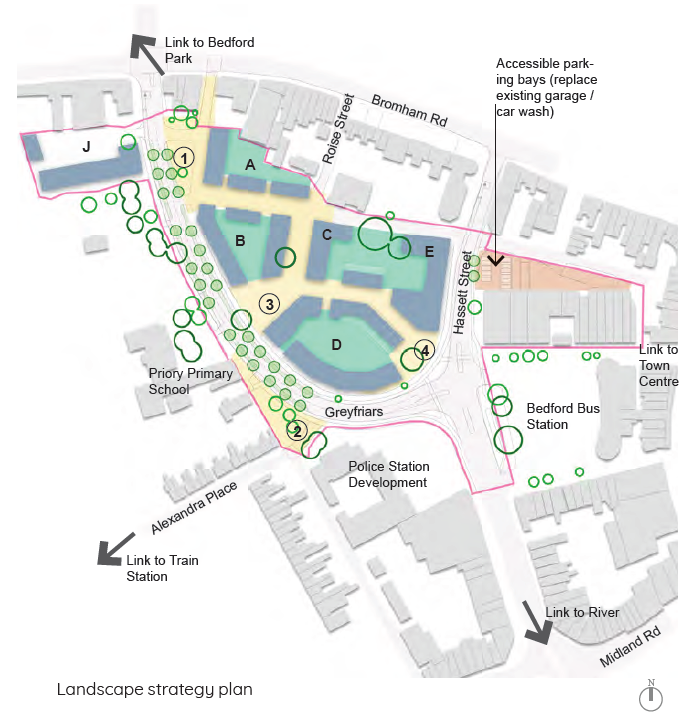
5.7 Landscape and public realm strategies
5.7.1 The Greyfriars masterplan landscape and public realm proposals should maximise opportunities to strengthen Bedford's green infrastructure and biodiversity resilience, helping address both climate and health challenges. The following public realm and landscape objectives are incorporated into the masterplan:
- Greyfriars road: Respond to the wider landscape context by reinforcing a green corridor from Bedford Park in the north, to River Great Ouse in the south. Reduce the scale of Greyfriars road by replacing superfluous carriageway or parking space, with places for soft landscape, pedestrians, and cyclists. The road should link new amenity spaces that would humanise this imposing piece of infrastructure and bring value to the local community.
- Existing Trees: Retention where possible of existing trees of good quality and high amenity value.
- Edge Conditions: Improve the thresholds to Priory Primary School and nursery, with a welcoming arrival space and enhanced pedestrian connections across Greyfriars road. Harmonise the interface to existing buildings on the northern boundary through a cohesive public realm design and potential rationalisation of adjacent site access.
- Public Open Space: Create meaningful areas of new public open space. The masterplan proposes two new public spaces including Community Gardens, co-located with the proposed commercial uses, and Hassett Street Plaza which acts as the bridging point into Bedford town centre. The purpose is to create an outstandingly attractive amenity for residents and visitors, gifting high quality public outdoor space to the wider community.
- Private Communal Amenity Space: Within the body of the site, private courtyards provide more usable amenity space for residents. These offer opportunities for play, growing and passive recreation to enhance the living environment.
- Biodiversity Enhancement: Landscape proposals should be underpinned by a richly diverse range of habitats, bringing nature to people's front door. This should include incorporating living roofs to all buildings.
- Sustainable Urban Drainage (SuDS): Water will be managed sustainably across the landscape via swales, rain gardens and permeable paving. Soft landscaping should be maximised to encourage natural infiltration.