Local Plan 2040 Draft Plan - Strategy options and draft policies consultation
3.0 Growth and spatial strategy options
Level of housing growth required
(144) 3.1 Government guidance sets out a standard method for calculating future housing requirements, which the Council must follow. As a result of the government's recent revisions to the standard method, the figure for Bedford borough currently is 1,275 dwellings per year, giving a total of 25,500 dwellings for the 20 year period from 2020 to 2040. This is the current starting point for the local plan housing requirement.
(16) 3.2 Existing commitments (planning permissions, allocations from current local plans and an allowance for windfall, which together total 13,000 dwellings) mean that based on the standard method figure of 1,275 dwellings p.a. the new local plan will need to allocate land to provide a minimum of 12,500 new dwellings. Further detail is set out in the evidence base document Local Housing Needs Assessment (LHNA), however it should be noted that the standard method number for the borough has been altered by recent affordability figures and the LHNA was produced in relation to the previous requirement of 1,305 dwellings p.a.
(12) 3.3 The annual requirement in the adopted Local Plan 2030 is 970 dwellings per year. The 1,275 figure for this new plan represents a substantial increase to the adopted plan and will bring with it considerable challenges. The standard method is calculated using inputs taken from household and affordability data which are updated regularly. This means that during the plan preparation period, as mentioned above, the Local Housing Need may change. We will therefore keep the Local Housing Need figure under review and will change the figure as necessary at the time that the plan for submission is prepared.
(88) 3.4 As well as setting the housing requirement for the plan period, the plan for submission will also include a trajectory to provide an indication of the timing of the delivery of the housing sites which are identified to meet the target. This will flow from the identification of the plan strategy and work on detailed site assessment and a greater understanding of the timing of the delivery of infrastructure needed to support growth.
(103) 3.5 Whilst more detailed work will be needed to determine this, we will consider whether, given the significant investment in infrastructure which would be necessary to deliver development in the borough at scale, a stepped trajectory approach may be appropriate for this plan. This could mean, for example, that the delivery target could be kept at 970 per year until 2030 and then increased to 1,580 dwellings per year to make up the rest of the plan requirement over the remaining 10 years. By 2030 the Black Cat Junction improvements will be complete, the East West Rail section through Bedford Borough will be complete (including new and re-modelled stations) and sufficient lead-in time will have been available for strategic projects to be planned in detail, enabling these higher numbers to be achieved. The forward planning will include arrangements for new sustainable travel links, with the intention that these are available from day one in order to embed and promote sustainable travel choices.
(8) 3.6 In addition to setting the overall quantum of housing which is to be provided, a local plan must also contain advice on the level and type of affordable housing which is needed and how the needs of particular groups (such as older people and those in need of accessible housing) are to be met. The LHNA also provides the evidence base to update the policies of the Local Plan 2030 on these matters. Policy 58S Affordable housing and 59S Housing mix will be updated once the viability of the local plan as a whole has been tested.
(5) 3.7 This consultation is, however, primarily concerned with:
- determining how much employment land needs to be planned for,
- how many homes need to be provided across the plan period,
- what infrastructure would be needed to support this growth and
- what, in the context of the vision and objectives outlined earlier in the document, is the appropriate spatial strategy for the plan.
Level of employment growth required
(76) 3.8 Taking account of planned population growth to 2040, the requirement for new employment land by that date is calculated to be 171 hectares (ha). Overall, the currently available supply of such land in the borough amounts to 48 ha leaving a requirement for 123 ha to be allocated in the local plan. Further detail on how this has been calculated is set out in the evidence base document Bedford Employment Land Study, March 2021, with a summary at paragraph 6.6 below.
(6) 3.9 The local plan must also plan for other growth requirements that may arise, for example additional shops and services, schools and transport infrastructure.
Growth strategy options
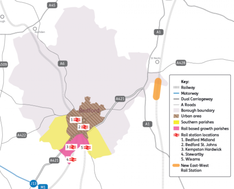
(65) 3.10 An important purpose of the local plan is to decide where in the borough growth should go. In last year's Issues and Options consultation the Council outlined six development locations which could form part of a strategy for growth. These were:
- Brown – Urban based growth
- Yellow – A421-based growth
- Pink – Rail-based growth
- Orange – East-West Rail northern station growth
- Grey – Dispersed growth
- Red – New settlement based growth
(74) 3.11 The responses to the issues and options consultation indicated that there was broad consensus favouring development focussed on the existing urban areas and the A421 corridor, and possible new railway stations which might be delivered on the new East-West Rail line. The responses are published in full on the Council's website at https://www.bedford.gov.uk/planning-and-building/planning-policy-its-purpose/local-plan-review/ and a summary of the issues raised along with the Council's response can be found in the document Issues & Options Consultation - summary and responses, see Table 1.
(66) 3.12 Following the 2020 consultation, the Council commissioned consultants to assess the likely effects of four development scenarios on traffic flows in the borough. That work is published as the evidence base document Bedford Borough Transport Model Local Plan Assessment Summary Report (see Table 1). The report explains that four spatial scenarios, chosen for highway testing purposes, were assessed and it provides a high-level comparison of spatial growth scenarios looking at seven key transport metrics and identifies the mitigation measures that would be required by each scenario. The report offers a comparison between scenarios. More detail on these scenarios is included in the Development Strategy Topic Paper.
(3) 3.13 Based on the building blocks of the development locations previously consulted upon, we have undertaken further work to define in more detail a range of potential alternative spatial strategies for the plan. These are set out in the Development Strategy Topic Paper, which also explains how they have been derived.
(18) 3.14 As a result of this work there are seven draft alternatives which vary in their focus, from concentrating growth in the urban area, to growth in villages and at new settlements in the A6 and A421 corridors. For some alternatives, more than one option is available.
(84) 3.15 Currently, based on work we have undertaken to date, the emerging preferred options (taken from the longer list in the Development Strategy Topic Paper) are below.
(152) 3.16 We would like your views on which of the alternatives / options should form the strategy of the local plan. We still have more work to do over the coming months to determine the best growth strategy for Bedford Borough and will take into consideration your comments before a decision is made. To help inform that decision, we have carried out an appraisal of the likely social, economic and environmental effects of each alternative and this may be helpful when considering the options. The results of that work are published as the Draft Sustainability Appraisal Report, May 2021 (see Table 1).
(239) 3.17 If you think that there are other strategies we should be considering, please let us know. These may be ones set out in the Development Strategy Topic Paper or completely different alternatives.
Option 2a: Development in and around the urban area, plus A421 transport corridor with rail based growth parishes and southern parishes.
- Within the urban area (1,500 dwellings).
- Adjoining the urban area (1,500 dwellings), up to 51 ha employment.
- Transport corridor – rail based growth: land within the parishes of Kempston Hardwick, Stewartby and Wixams (high option) (7,500 dwellings), up to 80 ha employment.
- Transport corridor – south: land within the parishes of Cotton End, Elstow, Kempston Rural, Shortstown, Wilstead and Wootton (2,000 dwellings).
- Total 12,500 dwellings and up to 131 ha employment
Option 2b: Development in and around the urban area, plus A421 transport corridor with rail based growth parishes and southern parishes, plus one new settlement.
- Within the urban area (1,500 dwellings).
- Adjoining the urban area (1,500 dwellings), up to 51 ha employment.
- Transport corridor – rail based growth: land within the parishes of Kempston Hardwick, Stewartby and Wixams (low option) (5,500 dwellings), up to 80 ha employment.
- Transport corridor – south: land within the parishes of Cotton End, Elstow, Kempston Rural, Shortstown, Wilstead and Wootton (1,500 dwellings).
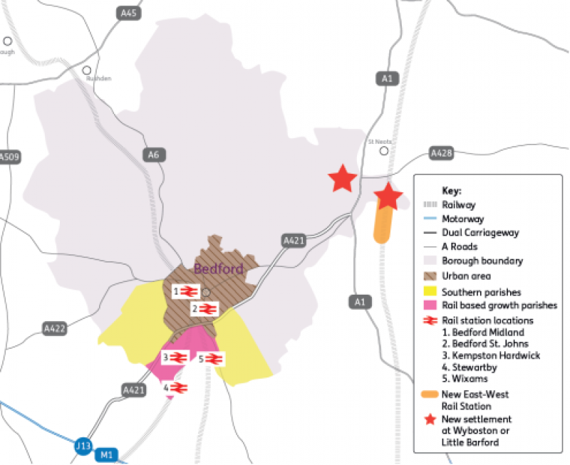
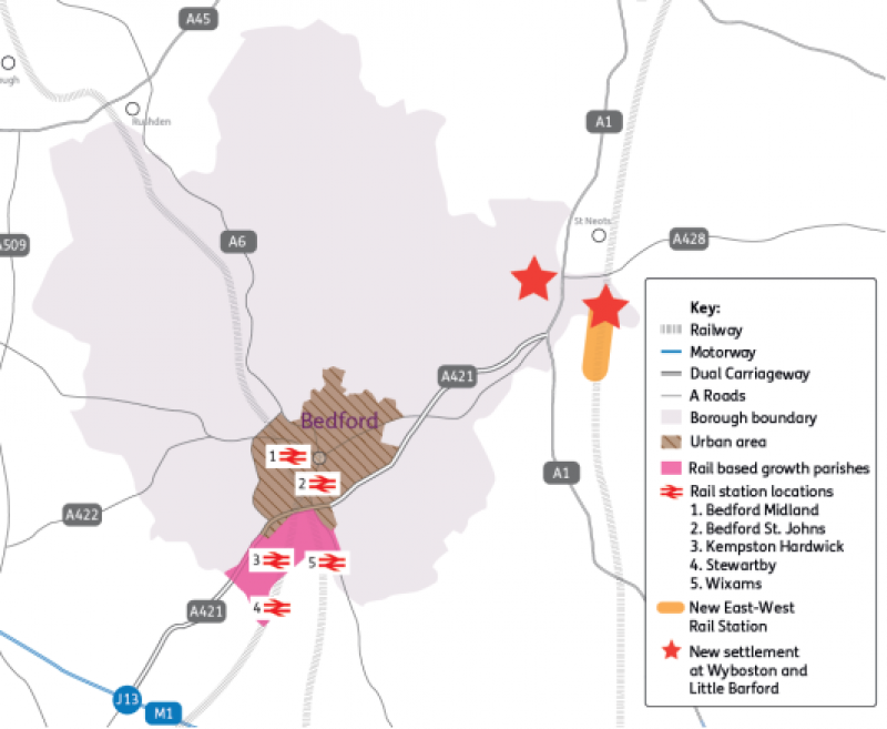
- New settlement at Little Barford (3,085 dwellings) or Wyboston (2,500 dwellings), up to 20 ha employment.
- Total between 12,500 and 13,085 dwellings and up to 151 ha employment.
Option 2c: Development in and around the urban area, plus A421 transport corridor with rail based growth parishes, plus two new settlements.
- Within the urban area (1,500 dwellings).
- Adjoining the urban area (1,500 dwellings), up to 51 ha employment.
- Transport corridor – rail based growth: land within the parishes of Kempston Hardwick, Stewartby and Wixams (extra low option, this being the residual required to meet need) (3,915 dwellings), up to 80 ha employment.
- New settlements at Little Barford (3,085 dwellings) and Wyboston (2,500 dwellings), up to 20 ha employment.
- Total 12,500 dwellings, up to 151 ha employment.
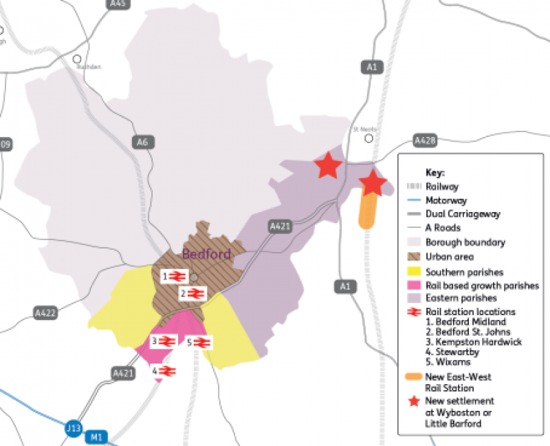
Option 2d: Development in and around the urban area, plus A421 transport corridor with rail based growth parishes, southern parishes and east parishes, plus one new settlement.
- Within the urban area (1,500 dwellings).
- Adjoining the urban area (1,500 dwellings), up to 51 ha employment.
- Transport corridor – rail based growth: land within the parishes of Kempston Hardwick, Stewartby and Wixams (low option) (5,500 dwellings), up to 80 ha employment.
- Transport corridor – south: land within the parishes of Cotton End, Elstow, Kempston Rural, Shortstown, Wilstead and Wootton (750 dwellings).
- Transport corridor – east: land within the parishes of Cardington, Cople, Great Barford, Little Barford, Roxton, Willington and Wyboston (750 dwellings), up to 28 ha employment.
- New settlement at Little Barford (3,085 dwellings) or Wyboston (2,500 dwellings), up to 20 ha employment.
- Total between 12,500 and 13,085 dwellings, up to 179 ha employment.
Transport Strategy
(10) 3.18 Bedford is part of the England's Economic Heartlands (EEH) Sub-National Transport Body. The EEH Transport Strategy provides an overall framework for transport policies and delivery across the region. It is drafted so that planning and highway authorities can develop their own suite of policies and plans which reflect their individual local issues.
(1) 3.19 However, the over-riding ambition set out in the Strategy is that we have entered a once in a lifetime opportunity to shape the transport future and deliver change. The basic premise for transport investment is that business as usual will not get us to where we want to be and will not enable the area to fulfil its economic and sustainable growth potential.
(5) 3.20 What this means is that in order to deliver sustainable growth; transport investment, travel behaviour and the way we think about moving around will need to change. The impact of continuing with current travel behaviour will have a detrimental impact on the very things that make the area successful, including the attractive environment and the network of small and medium sized towns and cities across the Oxford to Cambridge Arc.
(3) 3.21 Increased economic activity and growing populations, if left to continue in traditional patterns of movement and behaviour, will mean people spend longer on congested transport networks, the environment will be degraded, and quality of life expectations will not be met.
(16) 3.22 The EEH Strategy includes a five-point plan of action which is supported by Bedford Borough Council. The five actions are:
- Focus on decarbonisation of the transport system by harnessing innovation and supporting solutions which create green economic opportunities
- Promote investment in digital infrastructure as a means of improving connectivity, in order to reduce the need to travel
- Use delivery of East West Rail and mass rapid transit systems as the catalyst for the transformation of our strategic public transport networks
- Champion increased investment in active travel and shared transport solutions to improve local connectivity to ensure that everyone has the opportunity to realise their potential
- Ensure that our freight and logistics needs continue to be met whilst lowering the environmental impact of their delivery
(9) 3.23 Within Bedford, sustainable growth provides the context to deliver transport improvements for existing and new communities which reflect the ambitions of the EEH Transport Strategy. The following overarching principles provide a framework for Bedford's existing transport policies, and are able to support both the requirements to reduce the need to travel and the provision of good quality infrastructure which can support the needs of the economy and the environment:
Principle 1 - Support delivery of low carbon transport by working towards reduced congestion, digital connectivity, and a net zero carbon system by 2040
Principle 2 – Promote connectivity and accessibility in new development, and link new and existing communities
Principle 3 – Support opportunities for active travel and green infrastructure
Principle 4 – Promote and support infrastructure development which reflects the ambitions of the three preceding principles.
(3) 3.24 The current polices contained in the adopted development plan have been reviewed and are felt to be sufficiently robust to deliver the above principles. As a result they do not need to change. More detail can be found in the Development Strategy Topic Paper.
(60) 3.25 An initial review of the transport schemes needed to support local plan growth has been included in the scenario modelling undertaken by the Council's transport consultant and is available as appendices to the reports they have produced (see Table 1). Further work will be undertaken to inform the spatial strategy of the plan and the Infrastructure Delivery Report which will accompany it.
Housing development on small sites
(22) 3.26 The Council is required by the National Planning Policy Framework to deliver 10% of its housing requirement on small sites (sites no larger than one hectare). This is to create diversity in the type of sites that will be developed across the borough, encourage activity from smaller and medium sized businesses and generate a consistent year-on-year supply of houses, particularly when it is known that larger sites can have a significant lead in time before development commences.
(2) 3.27 Work has been undertaken to determine the number of completions delivered on sites of one hectare or less over recent years and this has demonstrated that there is a strong link between windfall and small sites' delivery for the borough. Development sites which have not been allocated as part of the local plan process are called 'windfall sites'. They normally comprise previously-developed sites that have unexpectedly become available. For the monitoring years 2015-2020 the number of dwellings built on small sites was consistently above 10% of the annual housing requirement. At 31 March 2020, 24.1% of housing supply was on small sites. Further detail is set out in the Small Sites Topic Paper.
(7) 3.28 As a consequence, the Local Plan 2040 will not include allocation policies for small sites simply to satisfy this specific requirement of government policy, as we expect sufficient small sites to continue to be delivered as a result of windfall development. Small sites may however be allocated in accordance with development strategy, once it is finalised.