Bedford Borough Local Plan 2040 Plan for Submission
4.0 Spatial strategy and site allocations
(5) 4.1 The spatial strategy is an important part of the local plan as it explains where homes and jobs will be delivered through new allocations. It also provides the framework for the determination of planning applications which come forward on unallocated sites. Certain strategic policies and allocations from Local Plan 2030 (listed in Appendix 1) are not being replaced by this local plan and therefore are taken into account as the spatial strategy is rolled on to 2040. Other policies and allocations are being replaced in response to the Council's updated vision and objectives.
(1) 4.2 The spatial strategy provides for the completion of strategic growth previously allocated in local plans and also in neighbourhood plans produced by Parish Councils. This previously allocated growth is located on a number of sites in and around the Bedford / Kempston urban area, in the rural area as extensions to certain key and rural service centres, and at the former Stewartby brickworks brownfield site.
(3) 4.3 In addition to this, the spatial strategy directs the further growth required to meet assessed needs to 2040 to locations that are currently accessible, or will become accessible during the period covered by the local plan. This means that new development will be focussed firstly on brownfield sites within the urban area and town centre regeneration opportunities. In addition, sites beyond, but close to, the urban area will give the opportunity for gains in green infrastructure. The completion of EWR will result in the creation of highly accessible locations around new rail stations. By concentrating on accessible locations, the spatial strategy aims to minimise the need to travel by car and therefore reduce the emission of carbon dioxide in line with the objectives of the plan. The growth locations are as follows:
- Within the urban area
- At strategic locations adjacent to the urban area which contribute to the delivery of key green infrastructure projects
- At new growth locations focussed on the EWR / A421 transport corridor with the potential for rail based growth, particularly in the south of Bedford area and at a new settlement at Little Barford.
(4) 4.4 Policy DS2 sets out a spatial strategy for the local plan that ensures the delivery of sufficient new development in sustainable locations to meet identified needs.
(93) Policy DS2(S) Spatial strategy
To deliver sustainable development and work towards making Bedford a net zero carbon emissions borough at the heart of the Oxford – Cambridge Arc, development will be focussed within the urban area, at specified strategic locations adjacent to the urban area and at growth locations within the A421 / East West Rail corridor. All new development will be required to contribute towards achieving the stated objectives and policies of this plan, in line with the Infrastructure Development Plan, through:
Within the urban area
- Maintaining and enhancing Bedford town centre as a vibrant and resilient location and multifunctional destination. Regenerating vacant spaces and including the establishment of an expanded residential and cultural quarter at Mayes Yard and town centre living at Greyfriars;
- Establishing a new station quarter and Midland Road gateway, including the redevelopment and regeneration of the area around Bedford Midland station to provide an academic and skills quarter and vibrant corridor between the town centre and rail station;
- Establishing vibrant new areas for urban living in Bedford's urban core at sites on Ampthill Road and on sites allocated in Local Plan 2030 including land south of the river and at Ford End Road;
- Making best use of brownfield and other available land within the urban area.
Strategic locations adjacent to the urban area which contribute to delivering the Bedford – Milton Keynes Waterway Park and the Bedford River Valley Park
- Residential-led development focussed at Gibraltar Corner and the Bedford River Valley Park north of the A603 which enhances and expands areas of green infrastructure and, in doing so, prevents coalescence between the urban area and existing settlements to protect their separate character and identity;
- Employment-led development at land south of Goldington Road.
Growth locations on the East West Rail / A421 transport corridor and with the potential for rail based growth
South of Bedford policy area
- Establishing an Arc-leading new settlement south of Bedford for innovation and an exemplar for landscape-led development and community building, based around the opportunity that the Stewartby Hardwick station on East-West Rail and the new Wixams station on the Midland Main Line presents;
- The completion of Wixams new settlement, incorporating eastern and southern extensions, and the development of a strategic village expansion utilising brownfield land at Kempston Hardwick identified in Local Plan 2030;
- An expansion of Shortstown to the west with active travel links to the rail network.
Little Barford area
- A new settlement and related employment provision at Little Barford well connected to the new East-West Rail station at its intersection with the East Coast Main Line.
Other employment sites
- Locations well-related to the strategic road and rail network that will deliver employment growth, making Bedford an attractive place to do business.
Rural area
- The completion of strategic Key Service Centre and more limited Rural Service Centre residential development identified in Local Plan 2030 on sites which are allocated in neighbourhood plans and the completion of Local Plan 2030 Policy 27 Land north of School Lane, Roxton;
- Safeguarding the intrinsic character of the countryside and the environment and biodiversity within it through the careful management of development to meet local needs whilst supporting the rural economy.
(1) 4.5 Further guidance on development in the rural area is provided by saved policies 4S-7S of Local Plan 2030.
The amount and timing of development
(1) 4.6 The development strategy has been informed by the need to meet the requirements for additional jobs and housing over the plan period.
Housing
(9) 4.7 Government guidance sets out a standard method for calculating future housing requirements which the Council must follow. As a result of the government's recent revisions to the standard method, the figure for Bedford borough currently is 1,355 dwellings per year, giving a total of 27,100 dwellings for the 20 year period from 2020 to 2040. This is the current starting point for the local plan housing requirement. Taking account of existing commitments, completions and an allowance for windfall, which amounts in total to 14,824 dwellings, this leaves 12,276 dwellings to be allocated in this plan.
(2) 4.8 The standard method approach to setting housing requirements uses inputs taken from population and affordability data. The Council's Local Housing Need Assessment (LHNA) and addendum demonstrate how these inputs are used to generate both the number of houses required and a dwelling-led population forecast which illustrates how the borough's population would change as new dwellings are delivered. It forecasts that an increase in population of around 50,000 people and in-migration of more than 22,000 people over and above existing trends will need to take place if dwellings are to be populated at the standard method rate of 1,355 dwellings per year. This represents a 40% increase on the housing requirement of 970 dwellings per year set in Local Plan 2030.
Gypsies, Travellers and Travelling Show People
(1) 4.9 The Gypsy & Traveller Accommodation Assessment (GTAA) for Bedford borough was published in November 2021. The Assessment provides a robust analysis of the current and future need for Gypsy, Traveller and Travelling Show People's accommodation in the borough in the years up to 2040. Full details are set out in the evidence base document GTAA.
4.10 In relation to Gypsies, Travellers and Travelling Show People, national policy draws a distinction between those who travel and those who do not and those who do travel have historically been referred to as meeting the 'planning definition'. However, the planning system must now make provision for those who travel and those who do not.
4.11 The additional needs of those members of the Gypsy and Traveller community who do not meet the planning definition are set out in the Local Housing Needs Assessment. However, the way that these needs are accommodated are in practice the same. Recent case law says that it is inappropriate to require any of the travelling community to live in bricks and mortar dwellings, and instead their needs should be met through the provision of plots and pitches.
(1) 4.12 In the plan period there is an identified need for an additional 46 Gypsy and Traveller pitches and 13 Travelling Show People plots which form part of the borough's overall housing need (they are not additional to it), as follows:
Table 2
|
Plan years |
0-5 |
6-10 |
11-15 |
16-20 |
Total |
|
2020-2025 |
2026-2030 |
2031-2035 |
2036-2040 |
||
|
Gypsies & Travellers (meeting definition) |
0 |
2 |
0 |
1 |
3 |
|
Gypsies & Travellers (not meeting definition) |
22 |
6 |
7 |
8 |
43 |
|
Total pitches |
22 |
8 |
7 |
9 |
46 |
|
|
|
|
|
|
|
|
Travelling Show People (all meet the definition) |
8 |
3 |
2 |
0 |
13 |
(1) 4.13 The Council is planning to meet this identified need and is progressing planning applications. Proposals will be assessed against Policy 64 Design of Gypsy, Traveller and Travelling Show People Sites. In addition, the new settlements at Kempston Hardwick (Policy HOU14) and Little Barford (Policy HOU17) and will include an allocation for gypsy and traveller pitches.
Transport Strategy
(2) 4.14 Bedford is part of the England's Economic Heartlands (EEH) Sub-National Transport Body. The EEH Transport Strategy provides an overall framework for transport policies and delivery across the region. It is drafted so that planning and highway authorities can develop their own suite of policies and plans which reflect their individual local issues.
4.15 However, the over-riding ambition set out in the Strategy is to shape the transport future and deliver change given the once in a lifetime opportunity presented. The basic premise for transport investment is that business as usual will not get us to where we need and want to be and will not enable the area to fulfil its economic and sustainable growth potential.
(2) 4.16 What this means is that in order to deliver sustainable growth; transport investment, travel behaviour and the way we think about moving around will need to change. The impact of continuing with current travel behaviour will have a detrimental impact on the very things that make the area successful, including the attractive environment and the network of small and medium sized towns and cities across the Arc.
(1) 4.17 Increased economic activity and growing populations, if left to continue in traditional patterns of movement and behaviour, will mean people spend longer on congested transport networks, the environment will be degraded, and quality of life expectations will not be met.
(3) 4.18 The EEH Strategy includes a five-point plan of action which is supported by the Council. The five actions are:
- Focus on decarbonisation of the transport system by harnessing innovation and supporting solutions which create green economic opportunities
- Promote investment in digital infrastructure as a means of improving connectivity, in order to reduce the need to travel
- Use delivery of EWR and mass rapid transit systems as the catalyst for the transformation of our strategic public transport networks
- Champion increased investment in active travel and shared transport solutions to improve local connectivity to ensure that everyone has the opportunity to realise their potential
- Ensure that our freight and logistics needs continue to be met whilst lowering the environmental impact of their delivery
(1) 4.19 Within Bedford, sustainable growth provides the context to deliver transport improvements for existing and new communities which reflect the ambitions of the EEH Transport Strategy which has four overarching principles:
- Principle 1 - Support the delivery of low carbon transport by working towards reduced congestion, digital connectivity, and a net zero carbon system by 2040
- Principle 2 – Promote connectivity and accessibility in new development, and link new and existing communities
- Principle 3 – Support opportunities for active travel and green infrastructure
- Principle 4 – Promote and support infrastructure development which reflects the ambitions of the three preceding principles.
4.20 National Highways has been commissioned by co-project sponsors the Department for Transport (DfT) and England's Economic Heartland (EEH), to undertake a study of the Oxford to Cambridge Arc Road connectivity. The purpose of the study is to identify where investment in key parts of the region's strategic road network is required in order to support existing identified locally planned growth in the area and alleviate existing issues and constraints on the network.
Infrastructure
(9) 4.21 An Infrastructure Delivery Plan (IDP) has been prepared to support the Local Plan 2040. It identifies the infrastructure required to meet the level of growth anticipated in the borough in a sustainable manner. The document covers all types of infrastructure from transport and mobility hubs to waste water and supply, energy to schools, health to police and fire services. The IDP identifies the infrastructure projects that will be required to meet the needs arising over the local plan period.
(1) 4.22 The borough faces a number of challenges which will impact on the timing of growth. These include the timing of the delivery of necessary infrastructure and the creation of economic drivers to act as a catalyst for growth and improve development viability in some parts of the borough, such as the town centre.
(4) 4.23 The potential of EWR to offer improved connectivity and create economic growth will be a critical catalyst for delivery and pivotal to achieving the plan's vision. The new links and stations however will not be operational until 2030 and other essential infrastructure (principally improvements to the A421) are expected to be delivered on similar timescales.
4.24 The Council's ambition is to establish Bedford as a place for innovation with an enhanced academic presence and new business / science parks linked to the attractiveness of locations served by the new rail stations, which will be essential in giving impetus to the housing market and housing delivery. These economic drivers, linked as they are to the delivery of EWR, will also take time to impact on in-migration and housing demand.
Stepped Trajectory
(4) 4.25 The significant increase in the housing requirement alongside the focus on new settlements and the infrastructure delivery challenges described above mean that housing provision across the plan period will need to be "stepped"; continuing at the same rate as it is for Local Plan 2030 for the first five years, with more significant growth post-2030 once critical infrastructure is delivered and the benefits for the local economy start to be felt.
4.26 Taking account of the infrastructure delivery challenges a stepped trajectory is proposed. The following policies set out the amount and timing of the delivery of growth to meet identified needs.
(2) 4.27 In the years up to 2030 housing supply is provided by sites allocated in Local Plan 2030 and early delivery on additional sites allocated in Local Plan 2040. After 2030, once EWR and highway improvements have been completed, the strategic growth sites allocated in this plan will be able to deliver substantial growth. Furthermore, development on some other urban sites also becomes increasingly viable. Given that the higher development rates in the second half of the plan period are primarily related to the provision of major infrastructure and strategic sites from 2030 onwards which is required to deliver them, there will be limited scope to bring forward sites to address any shortfall which may arise in the early years of the plan.
4.28 The Council will monitor the provision and delivery of infrastructure and, if necessary, bring forward a review of the local plan.
(56) Policy DS3(S) Amount and timing of housing growth
Provision of a minimum of 27,100 new dwellings will be stepped as follows:
|
2020/21 - 2024/25 |
2025/26 - 2029/30 |
2030/31 -2039/40 |
Total |
|
|
Dwellings (total) |
4,850 |
4,850 |
17,000 |
27,100 |
|
Dwellings (per annum) |
970 |
1,050 |
1,700 |
Five-year land supply will be measured against the stepped requirement which is applicable at the time of the assessment.
When undertaking the five-year supply calculation, should any shortfall arise it will be distributed across the remaining years of the plan period.
Employment
4.29 In determining the number of jobs to be planned for the Council has taken account of two key forecasts; one produced by the East of England Economic Forecasting Model (EEFM) and one based on the figures for economic activity taken from the dwelling led forecast derived from the standard method. There is a substantial difference between these two forecasts, indicative of the fact that the EEFM work does not reflect the substantial change in labour supply inherent in the standard method projection. The predicted number of jobs in the standard method forecast is included as a target reflective of the Council's commitment to providing a balance of homes and jobs in the borough and in the context of the plan vision and strategy creating a high-value, highly skilled, economy, expanding its current strengths, and developing into a location where innovative businesses can thrive.
(1) 4.30 The number of jobs is however a forecast and not a target. As explained in the Council's Economic Growth Ambitions paper the focus is on creating the right kind of jobs which will strengthen the local economy and create a prosperous future for the Borough and its residents. The jobs created will span a range of sectors and the jobs related to office, industrial and warehousing development (about 39% of the new jobs likely to be needed) will require the allocation of additional land. The Employment Land Study topic paper sets out that it is appropriate for the plan to identify between 118 and 142 ha of employment land. Policies HOU 12, HOU 19 and EMP 1 - EMP8, identify sufficient land to meet the upper end of this forecast. The number of hectares of land allocated is sensitive to the employment types being planned for as different land uses have different space requirements.
(6) Policy DS4(S) Amount of employment growth
Provision of up to 26,700 additional jobs to support the Council's ambition to create a high-value, highly skilled, economy, expanding its current strengths, and developing into a location where innovative businesses can thrive.
(1) 4.31 Policy DS5S sets out where growth will be located. It takes into account existing commitments together with the additional growth required to meet needs to 2040. There will continue to be growth in villages as a result of policies in the Local Plan 2030 which allocate growth to some Key Service Centres and Rural Service Centres. No new allocations are made in these villages in the Local Plan 2040, although some Parish Councils may choose to allocate further sites for development in their neighbourhood plans to meet particular local needs.
(45) Policy DS5(S) Distribution of growth
In accordance with Policies DS3(S) and DS4(S), growth will be distributed as follows:
|
Location |
Dwellings |
Employment land (ha) |
|
Within the urban area |
1,200 |
5* |
|
Strategic locations adjacent to the urban area which contribute to delivering the Forest of Marston Vale incorporating the Bedford Milton Keynes Waterway Park and the Bedford River Valley Park |
1,500 |
7 |
|
Growth locations on the A421 transport corridor and with the potential for rail based growth |
|
|
|
- South of Bedford including new settlement - Little Barford new settlement - Other employment sites |
7,050 3,800 - |
70 4 50 |
|
Some development will take place beyond the plan period |
400 |
|
|
Remaining rural area / villages |
Completion of sites previously allocated in local plans and neighbourhood plans |
|
*Does not include 20.4ha at Pear Tree Farm which is land allocated in ADLP Policy AD11 and counted as a commitment
(1) 4.32 The Council is also producing a Design Guide which will provide an overarching assessment of residential building design across the borough and contain design principles that will support the application of several design-related policies already in the development plan (28S, 29 and 30 LP2030). This will replace existing guidance which was prepared in 1997 and is in need of updating.
(1) 4.33 The Design Guide is also necessary in light of a new national emphasis on place-making, design and the creation of beautiful places. The NPPF was revised in July 2021, with references to the recently adopted National Design Guide and National Model Design Code included within it. Chapter 12 of the NPPF is titled 'Achieving well-designed places' and sets out the Government's policy priorities relating to good design and place making. Site allocations for the spatial areas are set out below. As specified in the site specific policies, for more complex sites the council will lead on the preparation of masterplans and design codes to be prepared in partnership with landowners. In other cases, there is a requirement for master plans and design codes to be prepared by the applicant and completed and approved by the Council before planning applications are submitted. The Council will produce a protocol which will inform the scope, content and process to be followed when preparing the masterplan and design coding documents.
Town centre
4.34 The Vision for the central Bedford town area is to create a number of key sites / quarters linked by the public realm improvements that are to be implemented through the Bedford Town Deal programme of works providing accessibility to the two EWR stations.
Bedford Midland Station and Bedford Academic Quarter
(1) 4.35 Bedford Midland station will be redeveloped as part of the EWR project but the precise location and configuration of the station is as yet unknown. The Council's Town Deal programme includes proposals to improve the public realm in the area, once the location is finalised. The vision is to create a gateway to the town linking the station to the town centre, including establishing a new Station Square as well as improving links for pedestrians and cyclists and the provision of a mobility hub with secure cycle parking and electric vehicle charging points, together with provision for public transport to integrate with the railway
4.36 Given its location at a key transport interchange and the nearby urban amenities that the centre of Bedford has to offer including workforce, retail, cultural and leisure assets set within the Bedford Conservation Area, this is also an excellent site on which to develop a knowledge hub. Set between the world-class academic centres of Oxford and Cambridge and with a new direct link to both, this is an exciting opportunity for the town.
4.37 As proposals for the station become clearer, there may be the potential for land at, and in proximity to, the current station to be configured to enable the creation of an academic quarter co-located with an innovation centre, and business incubator / spin-out space which would help increase educational attainment, retain local skills, upskill residents and create a knowledge-base from which start-up companies can grow and prosper.
4.38 Until such time as the EWR proposals are confirmed the impact on the Jowett sidings and Royal Mail land to the south of Midland road are unknown. For this reason, the Jowett sidings and Royal Mail sites are included as an opportunity site in accordance with Policy DS6.
(3) Policy EMP1 Land at Bedford Station, Bedford
The station area will be developed for a mix of uses including transport interchange residential, office, academic and retail uses. Key principles of development:
- As part of the town deal programme the Council will lead on the preparation of a masterplan and design code prior to the submission of any planning application for the site;
- The creation of a new mixed use academic quarter with offices, retail, residential and transport interchange and educational space to support the growth of spin-out companies linked to high-tech businesses based in the Oxford to Cambridge Arc benefiting from access to East West Rail;
- A new station entrance and public square and the creation of improved linkages to Midland Road;
- Re-provision of car and cycle parking including the potential for multi storey parking;
- Improvements to pedestrian access and public realm in Midland Road;
- Provision of revised station access arrangements via Ashburnham Road with a mobility hub and appropriate provision for bus, taxi / private hire vehicles, cycle and pedestrian access and drop-off / pick-up points;
- Contributions to town centre wide highway infrastructure improvements where required;
- Development should preserve and where opportunities arise enhance the setting of Bedford Conservation Area.
Ford End Road
(2) 4.39 The former industrial land and railway sidings located between the railway line and Marston's Eagle Brewery are already identified as a regeneration site and allocated within Local Plan 2030 (Policy 12).
(1) 4.40 The site's close proximity to Bedford Midland station provides a key residential opportunity. The land at Ford End Road has the potential to create a new residential quarter for circa 700 homes adjacent to the station, providing a combination of flats and houses with a public park and enhanced public access to the river corridor, designed to provide a range of unit types but with a focus on family homes. The location of the quarter, which would have a western pedestrian access to the new station would provide opportunities to create both build to rent and build for sale developments.
Greyfriars / Midland Road
(1) 4.41 The former Bedfordshire Police Station site and the adjacent mixed-use block at Greyfriars are already allocated for residential and town centre uses in Local Plan 2030 (Policy 11). The Policy 11 includes a requirement to replace the existing roundabout with traffic signals, which is being taken forward through the Town Deal.
4.42 The adjacent sites including the BPHA estate to the north, the Allhallows multi-storey car park, Greyfriars ground level car park and Saffron Close are allocated for redevelopment to provide homes with ground floor active uses.
4.43 Greyfriars is linked to the Bedford Midland station via Midland Road. Midland Road is characterised by a multi-ethnic collection of eating and shopping experiences, including Polish, South Asian and Chinese. The Bedford Town Deal programme includes funding for public realm works along Midland Road to create a more attractive, pedestrian-friendly environment and improve the quality of the shopfronts as the key approach from the station to the town centre.
4.44 A masterplan and design code will be prepared for this site and will be adopted as a Supplementary Planning Document (SPD). It is expected that work to inform the SPD (including any technical studies that are required) will be funded by the landowner / developer.
(4) Policy HOU1 Land at Greyfriars North, Bedford
Land at Greyfriars North will be developed for residential and appropriate town centre uses. Key principles of development include:
- A masterplan and design code to be prepared and adopted as a Supplementary Planning Document prior to the submission of any planning application for the site. The preparation of the Supplementary Planning Document will be led by the Council in partnership with landowners / developers, stakeholders and the local community. It should pay particular regard to ensuring that the development is designed to reflect the site's important location and to preserve the setting of heritage assets, including The Bedford Conservation Area, listed buildings fronting Bromham Road and other taller heritage assets in the town centre;
- Residential development with a mixture of retail and other town centre uses limited to ground floor fronting Hassett Street and Greenhill Street and Greyfriars to create an active frontage;
- Preparation of an access strategy;
- Provision of dedicated cycle routes and wide footways to reflect footfall and crossings to achieve pedestrian and cycle connectivity, whilst maintaining bus access;
- Provision of a mobility hub;
- Contributions to town centre wide highway infrastructure improvements where required;
- Pre-determination archaeological evaluation will be required for the areas of the site not already evaluated;
- Archaeological mitigation required ahead of development for those areas already evaluated;
- Financial contributions towards secondary school provision;
- A site specific flood risk assessment will be needed and mitigation required for all sources of flood risk where necessary. Opportunities to reduce surface water run-off and flood risk on and off site should be identified;
- Delivery of a low carbon and environmentally resilient development that is adaptive to and resilient to climate change;
- Early engagement with Anglian Water is required in order to identify connection to water network infrastructure.
Mayes Yard / St Paul's Square
(1) 4.45 The town centre continues to undergo structural change, which has been accelerated due to the Coronavirus Pandemic with greater reliance on online shopping. This has resulted in a number of major retailers falling into administration or retreating from the High Street.
4.46 Bedford has recently lost retailers including Beales department store, Debenhams, Marks & Spencer and Argos. At the Mayes Yard block, the closure of the Beales and Debenhams stores, and the presence of Council assets such as the library and the Corn Exchange provide an opportunity to redevelop and reconfigure buildings to create smaller units for retail, food and beverage occupiers, and residential opportunities at upper floors.
4.47 Plans include consideration of an expanded auditorium (from 800 to 1,200 seats) within the Corn Exchange to attract a greater range of regional-level shows to Bedford, and the potential for an updated library facility. The site could be opened up to create pedestrian browsing routes linking St. Paul's Square, Silver Street, High Street and The Higgins as well as delivering new residential dwellings.
(1) 4.48 This would complement other potential sites around St Paul's Square, such as the Court Building and the former Bank site adjacent to Town Bridge which are already allocated for development (Local Plan 2030 Policy 8). In addition, the Town Deal programme includes funding for public realm works at St Paul's Square. This will follow on from public realm improvement works at High Street and Silver Street Square which have recently been completed, and the current High Street Heritage Action Zone project. The Mayes Yard redevelopment would create a focus for this cultural quarter of the town centre linking to Castle Quay and The Higgins.
4.49 A design code will be required to assist in achieving an appropriately designed scheme in this important town centre location which takes into account sometimes conflicting issues including car parking, waste collection, servicing, and historic environment concerns.
4.50 A masterplan and design code will be prepared for this site and will be adopted as SPD. It is expected that work to inform the SPD (including any technical studies that are required) will be funded by the landowner / developer.
(4) Policy HOU2 Mayes Yard, High Street and Silver Street, Bedford
Land at Mayes Yard and between High Street and Silver Street, Bedford will be developed for a mix of uses to create an extended cultural quarter in this part of the town, including residential, hotel, retail and leisure. Key principles of development include:
- A masterplan and design code to be prepared and adopted as a Supplementary Planning Document prior to the submission of any planning application for the site. The preparation of the Supplementary Planning Document will be led by the Council in partnership with landowners / developers, stakeholders and the local community;
- Provision of residential and / or hotel on upper floors;
- Scheme to involve conversion, redevelopment and new buildings including the reconfiguration of the site currently occupied by Bedford Corn Exchange;
- Preparation of an access strategy;
- Heritage impact assessment must be submitted to the Council as a first stage of the masterplanning process;
- Any new development must contribute positively to local character and distinctiveness and enhance or better reveal the significance of the conservation area and setting of any listed buildings;
- Any new development will need to ensure the preservation of the scheduled monument of the 'Remains of the George Inn' and include measures for its conservation and public interpretation, and where opportunities arise, enhancements to its setting;
- Pre-determination archaeological evaluation will be required;
- Financial contributions towards secondary school provision;
- Delivery of a low carbon and environmentally resilient development that is adaptive to and resilient to climate change;
- Early engagement with Anglian Water is required in order to identify connection to water network infrastructure.
South of the River / Bedford St Johns Station
(2) 4.51 This is currently a large area with low density uses, industrial premises, car parks, and railway land south of the river between Cauldwell Street and Elstow Road around Bedford St Johns station.
(1) 4.52 The vision is for a residential-led mixed-use quarter around a new Bedford St Johns station to be constructed by EWR with the railway closer to the Hospital, creating a Station Square and a development area around Melbourne Street with a key thoroughfare from the station through Kingsway to the town centre, and this development area is already allocated for development (Local Plan 2030 Policy 14).
4.53 The land has capacity for in the region of 1,000 dwellings, which reflects densities for a high proportion of flats (80-85%) around the transport hub with building heights of up to five / six storeys and integrated high quality public open space. The area provides opportunities for a mix of residential products including build to rent and retirement living, together with build for sale. Active ground floor uses are promoted especially on the primary streets for a range of activities within Use Class E.
(1) 4.54 The residential quarter to be created around Bedford St Johns station could have an Italian influence to celebrate the town's rich historical links with Italy. The land at Britannia Road provides potential for Bedford Hospital to expand to accommodate planned growth, including a new multi-storey car park and attractive links to Bedford St Johns station. A development brief for the area is currently being prepared.
Southern Gateway (Ampthill Road and Kempston Road approaches to the town centre)
4.55 This southern approach to the town centre presents on opportunity to create a further new neighbourhood for urban living which will incorporate greenspace in the form of a new urban park. Between the development site boundary and the Midland Main Line can be found operational railway sidings and a range of employment uses, including a scrap yard, which will need to be taken into consideration. The area would benefit from a comprehensive approach and there may be potential for additional land / uses adjacent to the allocated site to be considered for re-development as part of the master planning of this area.
4.56 A masterplan and design code will be prepared for this site and will be adopted as SPD. It is expected that work to inform the SPD (including any technical studies that are required) will be funded by the landowner / developer.
(4) Policy HOU3 Land at Ampthill Road, Bedford
Land at the former Camford Works and Technology House on Ampthill Road, Bedford will be developed for a mix of residential and business uses. Key principles of development include:
- A masterplan and design code to be prepared and adopted as a Supplementary Planning Document prior to the submission of any planning application for the site. The preparation of the Supplementary Planning Document will be led by the Council in partnership with landowners / developers, stakeholders and the local community. It will pay particular regard to adjacent noise sources;
- Provision of a mix of dwelling types and sizes;
- Provision of greenspace in the form of a new urban park;
- Preparation of an access strategy to include all modes;
- Provision of a vehicular and safe pedestrian connection between the site and Cauldwell School;
- Provision of a mobility hub;
- Provision of a layout which takes full account of the noise environment relative to the railway line and neighbouring land uses;
- Pre-determination archaeological evaluation will be required;
- Financial contributions towards secondary school provision;
- A site specific flood risk assessment will be needed and mitigation required for all sources of flood risk where necessary;
- Opportunities to reduce surface water run-off and flood risk on and off site should be identified;
- Assessment of the nature and extent of ground contamination and preparation of a remediation strategy for the site including methods of disposing of contaminated material, measures to prevent pollution of surface and ground water and provisions for future monitoring, to be approved by the Council;
- Delivery of a low carbon and environmentally resilient development that is adaptive to and resilient to climate change;
- Early engagement with Anglian Water is required in order to identify connection to water network infrastructure.
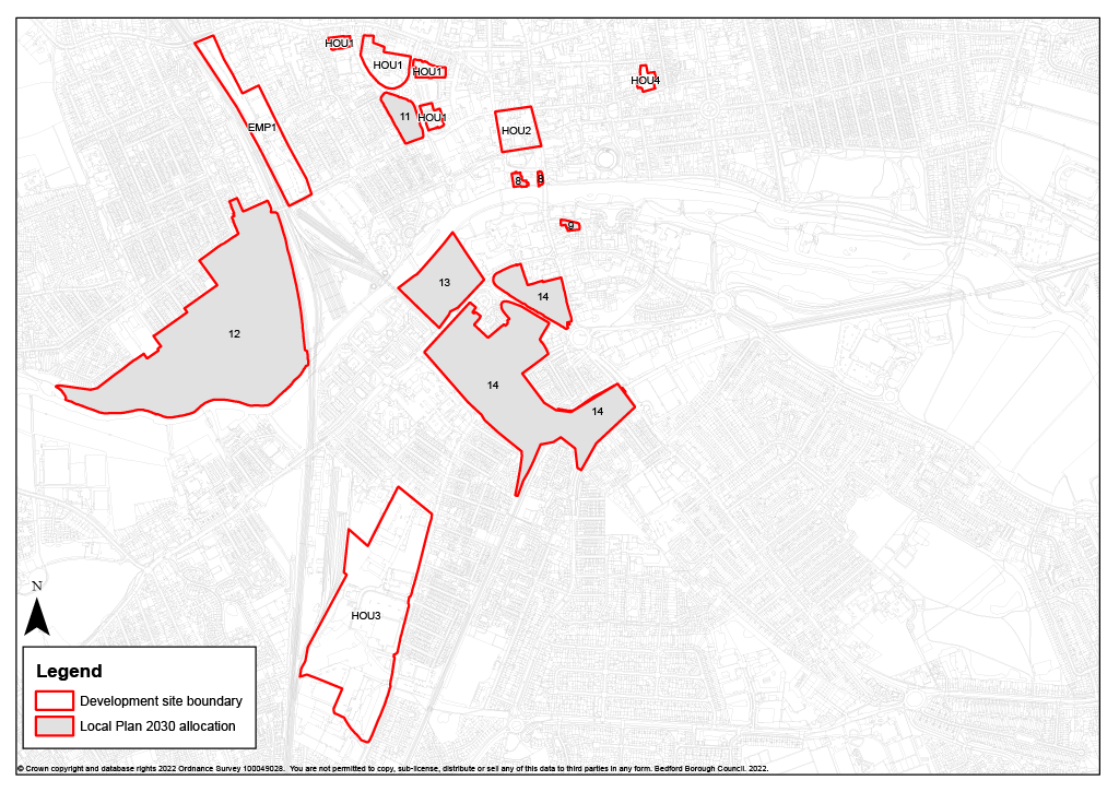
Figure 2: Town Centre sites: Local Plan 2030 allocations and Local Plan 2040 sites
Other Urban Sites
4.57 The site formerly used by Peacocks auction house on Newnham Street Bedford is allocated for residential development. The site is well-located just beyond the town centre boundary, close to services and facilities both in the town centre and along Castle Road. Within the conservation area, the site currently contains a mixture of buildings and its development offers the opportunity to transform the site with an attractive residential scheme which is sensitive to the historic setting.
(2) Policy HOU4 Former Peacocks Auction House, Newnham Street, Bedford
Land at the former Peacocks Auction House, Newnham Street, Bedford will be developed for residential use. Key principles of development include:
- Preparation by the applicant of a masterplan and design code to be completed prior to and submitted with any planning application, and to pay particular regard to the site's relationship with the conservation area and surrounding listed buildings at 2-28 The Grove and 12-16 Newnham Street;
- Provision of a mix of dwelling types and sizes to be accessed from Newnham Street;
- Development should include two storey frontage development addressing Newnham Street and subservient development to the rear;
- Development should preserve and, where opportunities arise, enhance heritage assets and their settings, including:
- The Bedford Conservation Area
- Grade II 2-28 The Grove
- Grade II 12-16 Newnham Street;
- Preparation of an access strategy;
- Reinstatement of the highway frontage to match surrounding area;
- Financial contributions towards secondary school provision;
- Assessment of the nature and extent of ground contamination and preparation of a remediation strategy for the site including methods of disposing of contaminated material, measures to prevent pollution of surface and ground water and provisions for future monitoring, to be approved by the Council;
- Pre-determination archaeological evaluation will be required;
- Delivery of a low carbon and environmentally resilient development that is adaptive to and resilient to climate change.
Land at Abbey Field, West of Elstow
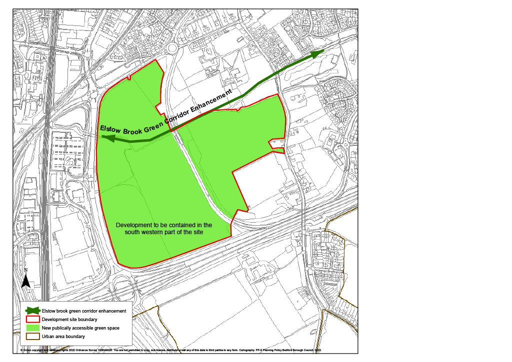
(3) 4.58 The importance of retaining the separate identity of Elstow is recognised. Development contained within the south western corner of the site will facilitate the protection in perpetuity of the area to the north as strategic green space which offers views across to Elstow Abbey as well as opening the area up to public and the creation of a walk alongside the Elstow Brook. To be developed with an appropriate vernacular architecture that reflects its location within the landscape setting of historic Elstow.
(36) Policy HOU5 Abbey Field, West of Elstow
Land at Abbey Field, will be developed for residential use and provide public access to existing urban open space, linking into the Elstow Brook corridor. Key principles of development include:
- Preparation by the applicant of a masterplan and design code to be completed prior to and submitted with any planning application, to pay particular regard to:
- ensuring that the development is designed to reflect the site's important location and to preserve the setting of heritage assets where possible,
- ensuring development will be contained west of Abbey Fields and south of the Elstow Brook, with significant open space to the north and east of the development site to open up the Elstow Brook corridor and the wider area for public access from which views of the Abbey and the scheduled monument of Elstow Manor House (remains of) can be enjoyed,
- identifying opportunities to enhance green infrastructure including connections to existing networks,
- identifying and mitigating noise pollution from adjoining road and nearby industrial development.
- Provision of a mix of dwelling types and sizes to be accessed from Abbey Fields;
- Preparation of an access strategy to include:
- Provision of a pedestrian / cycle bridge across the A421 between the site and Pear Tree Farm,
- Provision of pedestrian and cycle routes through the site and along Abbey Fields and safe crossing points to facilitate connections with the wider network including at Progress Park, West End and Wilstead Roads facilitating connections to / from the South of Bedford Policy area.
- Financial contributions towards secondary school provision;
- Pre-determination archaeological evaluation will be required;
- A site specific flood risk assessment will be needed and mitigation required for all sources of flood risk where necessary. Opportunities to reduce surface water run-off and flood risk on and off site should be identified;
- An assessment of the site-specific ecological impacts of the proposal to be undertaken prior to the submission of any planning application;
- Delivery of a low carbon and environmentally resilient development that is adaptive to and resilient to climate change;
- Early engagement with Anglian Water is required in order to identify connection to water network infrastructure.
Figure 3: Abbey Field West of Elstow
The Cloisters, Church Lane, Bedford
(1) 4.59 Redevelopment of land at Bury Court currently containing garage blocks, a church hall and the vicarage provides the opportunity for an additional access north to Elliot Crescent and also the relocation of the church hall. Development of the area is to be influenced by and enhance the adjacent St. Mary's Church and design out existing anti-social behaviour experienced on the site. The site offers the opportunity to include additional pedestrian access routes and areas of public open space and a community garden framing views to the church.
(3) Policy HOU6 The Cloisters, Church Lane, Bedford
Land at Bury Court, Church Lane, Bedford will be developed for residential use and include the relocation of the church hall with access onto Church Lane. Key principles of development include:
- Preparation by the applicant of a masterplan and design code to be completed prior to and submitted with any planning application to pay particular regard to the site's important location to preserve the setting of heritage assets and existing veteran trees along the western boundary;
- Development should where possible preserve, and where opportunities arise, enhance the significance of Grade II* St. Mary's Church and the contribution made by setting to significance;
- Development will be limited to a two storey height and public open space provided along the western boundary adjacent to the churchyard to preserve a spatial buffer from views of St Mary's Church within the churchyard;
- Provision of a range of housing types and sizes;
- Improvements to transportation networks, including widening and surface improvements to existing pavements to accommodate wheelchair users (approx. 10m);
- Retention of connections to existing pedestrian and cycle routes via The Copse / The Spinney / Bury Walk to the east;
- Widening of the existing pedestrian cycleway south across Goldington Green to improve cycle connectivity and north along Church Lane to Queens Drive;
- Financial contributions towards secondary school provision;
- Identification of opportunities to enhance green infrastructure including connections to existing networks and increased public access routes to increase natural surveillance;
- Pre-determination archaeological evaluation will be required;
- A site specific flood risk assessment will be needed and mitigation required for all sources of flood risk where necessary. Opportunities to reduce surface water run-off and flood risk on and off site should be identified;
- Delivery of a low carbon and environmentally resilient development that is adaptive to and resilient to climate change.
Williamson Road, Kempston
4.60 Land to the south west side of Williamson Road is situated next to Kempston Challenger Academy, in the middle of Kempston. It is immediately surrounded by residential and educational uses. There is an established the cycleway to the north. The site can deliver a well-connected, urban residential development.
(3) Policy HOU7 Land at Williamson Road, Kempston
Land on the south west side of Williamson Road, Kempston will be development for residential use. Key principles of development:
- Provision of a range of housing types and sizes;
- Submission of noise survey to determine and mitigate the effects of the neighbouring Challenger Academy on development;
- Suitable access arrangements and appropriate pedestrian and cycle connectivity to existing infrastructure required;
- Suitable landscaping to take account of neighbouring Challenger Academy;
- Financial contributions towards secondary school provision;
- Opportunities to reduce surface water run-off and flood risk on and off site should be identified;
- Delivery of a low carbon and environmentally resilient development that is adaptive to and resilient to climate change.
Land adjacent to Police Headquarters, Woburn Road, Kempston
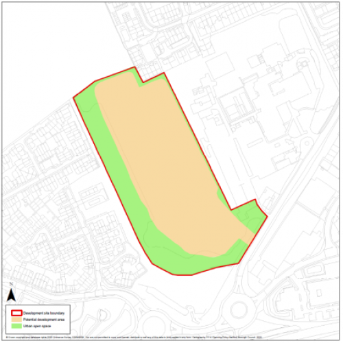
4.61 The site adjacent to the Police Headquarters offers the opportunity for additional residential development within the urban area. Formerly playing fields used by the sports and social club, the site has not been used for recreational purposes for some time and has been partly used for car parking since 2011. An additional access road has recently been built – initially to serve the new custody suite located on the main Police HQ site.
4.62 The site is designated as an Urban Open Space. The reasons for designation were that the site provides a green break in the built up area and also provides a linkage with the playing fields at KCA to the north. It will be possible to design the site to retain the green break as seen from Woburn Road, through the careful design and location of open space within the site. In addition, the treed area along the western boundary will be retained and a landscape buffer created between the site and the custody suite on the eastern boundary. These will provide wildlife corridor and green infrastructure connections to the playing fields to the north as required by Policy AD43.
(4) Policy HOU8 Land west of Police Headquarters, Woburn Road, Kempston
Land to the west of the Police Headquarters, Kempston will be developed for residential use and open space. Key principles of development include:
- Preparation by the applicant of a masterplan and design code to be completed prior to and submitted with any planning application and to pay particular regard to the comprehensive consideration of green space and access to it;
- Provision of a range of housing types and sizes;
- Submission of a wildlife and habitat survey with appropriate mitigation and enhancements;
- Suitable siting of development and landscaping to take account of surrounding uses;
- Development should preserve and where opportunities arise, enhance the significance of Grade II Sailors Bridge Cottages;
- Pre-determination archaeological evaluation will be required;
- Provision of a Transport Assessment demonstrating suitable access and detailing assessment of impact on surrounding highways, and identifying mitigations measures where required;
- Provision of pedestrian and cycle links through the site to improve access to surrounding green infrastructure and connections to existing networks to the surrounding residential areas;
- Provision of improvements to pedestrian and cycle route running along the B531 north to Kempston and south to employment areas;
- Financial contributions towards secondary school provision;
- A site specific flood risk assessment will be needed and mitigation required for all sources of flood risk where necessary;
- Opportunities to reduce surface water run-off and flood risk on and off site should be identified;
- Delivery of a low carbon and environmentally resilient development that is adaptive to and resilient to climate change.
Figure 4: Land West of Police Headquarters, Kempston
Land at Chantry Avenue
(1) 4.63 This site at Chantry Avenue has been derelict for many years. The development of this previously developed site in the urban area offers the opportunity to enhance the local environment. Located between a residential area and an industrial estate, planning permission will be permitted for a layout that designs out the likely harm to the amenity of future residents and this is achievable with careful design of the site including the orientation of the buildings and their windows and noise attenuation fencing along southern and western boundaries.
(3) Policy HOU9 Land at Chantry Avenue, Kempston
Land at Chantry Avenue, Kempston will be developed for residential use. Key principles of development include:
- Preparation by the applicant of a masterplan and design code to be completed prior to and submitted with any planning application and to pay particular regard to adjacent noise sources;
- Provision of a mix of dwelling types and sizes to be accessed from Chantry Avenue;
- Submission of a Transport Assessment to include measures to mitigate impact of the development on the highway network and to maximise opportunities for sustainable travel;
- Financial contributions towards secondary school provision;
- A site specific flood risk assessment will be needed and mitigation required for all sources of flood risk where necessary; Opportunities to reduce surface water run-off and flood risk on and off site should be identified;
- Delivery of a low carbon and environmentally resilient development that is adaptive to and resilient to climate change.
The council would be supportive of an element of live / work units on this site.
Land at Bedford Heights, Manton Lane, Bedford
(1) 4.64 The site offers the opportunity to make use of an area of surplus car parking. The housing mix and massing will need to have regard to the impact of development in this elevated location.
(8) Policy HOU10 Land at Bedford Heights, Manton Lane, Bedford
Part of Bedford Heights car park, Bedford will be developed for residential use. Key principles of development include:
- Preparation by the applicant of a masterplan and design code to be complete prior to and submitted with any planning application and to pay particular attention to the adjacent noise sources, layout and massing of the site having regard to its elevated location;
- Access from Brickhill Drive;
- Provision of safe pedestrian and cycle links to adjacent networks;
- Landscaping on and around the site to soften the interface with the adjacent car park;
- Financial contributions towards secondary school provision;
- Delivery of a low carbon and environmentally resilient development that is adaptive to and resilient to climate change;
- Early engagement with Anglian Water is required in order to identify connection to water network infrastructure.
Former playing field, ARA, Manton Lane, Bedford
4.65 The former playing field of the Aircraft Research Association provides an opportunity to extend the existing employment area around Manton Lane and provide a range of employment uses suited to this urban setting. As the site lies on the edge of the town, its development will allow landscaping and pedestrian access improvements to be delivered. The height of the development should be restricted because of the site's location on high ground.
(2) Policy EMP2 Former playing field, ARA Manton Lane, Bedford
Land at the former playing field, ARA Manton Lane will be developed for industrial, warehousing and distribution uses. Key principles of development include:
- Preparation by the applicant of a masterplan and design code to be completed prior to and submitted with any planning application and to pay particular regard to landscape and visual impact issues;
- 1.6 hectares employment site;
- Landscape and visual impact assessment to be submitted;
- Submission of a Transport Assessment to assess the impact of the development on Manton Lane / Brickhill Drive signal junction, to explore opportunities to maximise sustainable travel improvements and to accommodate all parking within the site.
- Pre-determination archaeological evaluation will be required;
- A site specific flood risk assessment will be needed and mitigation required for all sources of flood risk where necessary;
- Delivery of a low carbon and environmentally resilient development that is adaptive to and resilient to climate change;
- Early engagement with Anglian Water is required in order to identify connection to water network infrastructure.
Land south west of Interchange Retail Park
4.66 The land south west of Interchange Retail Park between the A421 and railway is within the urban area and currently occupied by a radio transmission mast. This is shortly to become non-operational, giving the opportunity to develop this area for a range of employment uses.
(3) Policy EMP3 Land south west of Interchange Retail Park and north of A421, Kempston
Land south west of Interchange Retail Park and north of A421 will be developed for industrial, warehousing and distribution uses. Key principles of development include:
- 3.3 hectares employment site;
- Submission of a Transport Assessment to identify the impact of traffic on the B530 / Polo Field Way roundabout and Cow Bridge, and identifying mitigation measures where required which ensure access for both pedestrians and cyclists to ensure sustainable travel to / from the development;
- Access from Interchange Way;
- Provision of pedestrian and cycle links to the Interchange Retail Park, Woburn Road industrial estate, Cow Bridge and Ampthill Road;
- Pre-determination archaeological evaluation will be required;
- A site specific flood risk assessment will be needed and mitigation required for all sources of flood risk where necessary; Opportunities to reduce surface water run-off and flood risk on and off site should be identified;
- Delivery of a low carbon and environmentally resilient development that is adaptive to and resilient to climate change;
- Early engagement with Anglian Water is required in order to identify connection to water network infrastructure.
Land south of Goldington Road, Bedford
4.67 This site is well-located on the edge of the urban area and adjoining the existing Elms Farm industrial estate. Its position on the edge of Bedford means that it has good access to the strategic road network and is suitable for a range of employment uses. The site adjoins the River Great Ouse and there are opportunities for the site to contribute to achieving the objectives of the Bedford River Valley Park (Policy AD26).
(8) Policy EMP4 Land south of Goldington Road, Bedford
Land south of Goldington Road will be developed for office, industrial, warehousing and distribution uses. Key principles of development include:
- Development to be guided by a masterplan and design code to be completed by the applicant prior to and submitted with any planning application and to pay particular regard to the importance of this location as a gateway to Bedford;
- 7.2 hectares employment site;
- Contribution to achieving the objectives of the Bedford River Valley Park (Policy AD26);
- Development should where possible preserve and where opportunities arise enhance the significance of heritage assets associated with the Howbury Hall Estate and the regionally significant Risinghoe Castle and the contribution made by their settings;
- Pre-determination archaeological evaluation will be required;
- Submission of a biodiversity report with appropriate mitigations;
- Submission of a Transport Assessment to include the need for mitigation on the adjacent highway and measures to ensure sustainable travel to / from the development;
- A site specific flood risk assessment will be needed and mitigation required for all sources of flood risk where necessary; Opportunities to reduce surface water run-off and flood risk on and off site should be identified;
- Delivery of a low carbon and environmentally resilient development that is adaptive to and resilient to climate change;
- Early engagement with Anglian Water is required in order to identify connection to water network infrastructure.
Residential Opportunity Sites
4.68 In past local plans, the Council has identified 'Opportunity Sites'. These are sites that are in locations suitable for development, usually the urban area, but where specific technical issues prevent positive allocations being made. The reason for identifying them has been to promote their availability and invite the development industry to work with us to find ways of addressing the sites' constraints.
4.69 Through work on the local plans 2030 and 2040 the Council has been able to resolve many of those technical matters and most of the former opportunity sites are either an allocation in this plan or have planning permission and are counted as commitments. However, the Bedford Blues site still has outstanding technical issues. If these can be resolved, the site will provide additional development capacity in the urban area.
4.70 The inclusion of an additional site currently occupied by the Royal Mail delivery office would increase the number of residential units that could be delivered within close proximity to the station. For this reason, the Jowett Sidings and Royal Mail sites are included as an opportunity site in accordance with Policy DS6 (which replaces Local Plan 2030 Policy 26). The Town Deal programme, includes funding for works around Midland station designed to develop a gateway to the town and promote sustainable travel. More information about opportunity sites is given in Appendix 3.
(2) Policy DS6 Opportunity Sites
Within the urban area a number of opportunity sites have been identified that have redevelopment potential for housing development. These are described in Appendix 3. The Council will work with land owners and other interested parties to investigate such opportunities and bring them forward through the development management process where possible.
Adjacent to the urban area
(2) 4.71 Two residential allocations adjacent to the urban area are included in the plan because they provide the opportunity to help deliver two of the Council's strategic green and blue infrastructure priorities alongside residential development.
Gibraltar Corner
(5) 4.72 An allocation for residential development is made at Gibraltar Corner. As well as being adjacent to the urban area, Gibraltar Corner also falls within the South of Bedford policy area and the allocation policy is contained in the policies dealing with that area (see Policy HOU13 below). The dual status of the site has no strategic significance. A new settlement policy area has been defined which maintains the area's separate character and prevents coalescence with other settlement including the urban area. Development here benefits from good links with Bedford and the opportunity to access rail stations. It also delivers significant green and blue infrastructure improvements including a section of the Bedford to Milton Keynes Waterway Park and additional planting areas contributing to the Forest of Marston Vale.
Bedford River Valley Park
4.73 Enabling development at Bedford River Valley Park has been allocated in the development plan for a number of years in order to finance the delivery of a watersports lake and other leisure opportunities (Allocations & Designations Local Plan Policy AD23). Whilst planning permission for the watersports lake has been granted and development legally commenced, the project has progressed no further. The enabling development hasn't happened, but the Council's aspiration to deliver the lake and leisure uses in support of wider growth in the borough remains a priority.
4.74 A new scheme has been drawn up to take the project forward. Whilst the original enabling development envisaged employment, leisure and education uses on the site with the possibility of a continuing care retirement community, the refreshed scheme will deliver a mixed use development including residential units, an education facility, a care home, and watersports lake set in a well landscaped, multi-functional greenspace to serve the recreational needs of Bedford's expanding population. Development of the site will enable the consolidation of a number of piecemeal areas of green infrastructure and will foster biodiversity improvements through habitat creation and sensitive landscaping.
4.75 The development will become a gateway into the eastern side of Bedford providing pedestrian and cycle links connecting into the existing networks. The area has high archaeological significance which will be enhanced and interpreted for the benefit of the wider public. Policy AD26 sets the Bedford River Valley Park Framework. The watersports lake will become a multi-activity area for local residents, as well as providing a regional facility for watersports events.
4.76 A masterplan and design code will be prepared for this site and will be adopted as SPD. It is expected that work to inform the SPD (including any technical studies that are required) will be funded by the landowner / developer.
(5) Policy HOU11 Land at Bedford River Valley Park
Land at Bedford River Valley Park will be developed for a mix of residential, education, open space and recreational uses including the delivery of a watersports lake and strategic green infrastructure improvements. Key principles of development include:
- A masterplan and design code to be prepared and adopted as a Supplementary Planning Document prior to the submission of any planning application for the site. The preparation of the Supplementary Planning Document will be led by the Council in partnership with landowners / developers, stakeholders and the local community;
- Delivery of a mix of residential units;
- Submission of a Transport Assessment detailing impact on the surrounding highway network, necessary mitigations and opportunities for internal and external connectivity and active and low carbon travel;
- Provision of two vehicular access points onto the A603;
- Provision of pedestrian and cycle routes and links to existing networks including NCN51;
- Provision of a mobility hub;
- Provision of a serviced site with a minimum area of 2.4 ha to accommodate a two form entry primary school and to include early years' provision;
- Financial contributions to secondary school provision;
- Delivery of a watersports lake before the completion of the 500th dwelling appropriate for regional standard events and associated infrastructure including boat house, club house and adequate car parking;
- Provision of links to existing green infrastructure networks;
- Masterplan to ensure that development is designed to preserve and where opportunities arise, enhance the significance of heritage assets and the contribution made by setting, including for
- Grade II Octagon Farmhouse
- Grade II Dog House
- Assets within Willington including the Scheduled Stables and Dovecote, and Grade II St Lawrence Church;
- The retention and appropriate reuse of Octagon Farmhouse and its outbuildings as part of the overall development;
- A buffer should be provided between the scheduled monument, 'Two Barrows' 500m NE of Octagon Farm and the cycle path proposed ensuring that the significance of the asset is not harmed by redevelopment through physical impacts of redevelopment;
- Pre-determination archaeological evaluation in areas not previously subject to quarrying or archaeological investigation;
- Investigation into the diversion of Elstow Brook in consultation with the Internal Drainage Board;
- A site specific flood risk assessment will be needed and mitigation required for all sources of flood risk where necessary. Opportunities to reduce surface water run-off and flood risk on and off site should be identified;
- Contribution to the Forest of Marston Vale with a minimum of 30% tree cover to be provided on the site;
- Submission of a wildlife and habitat survey with appropriate mitigation and enhancements;
- Delivery of a low carbon and environmentally resilient development that is adaptive to and resilient to climate change;
- Early engagement with Anglian Water is required in order to identify connection to water network infrastructure;
- Investigation of opportunities for a district heating network associated with the nearby Water Recycling Centre.
Growth locations on the EWR / A421 transport corridor and with the potential for rail-based growth
South of Bedford
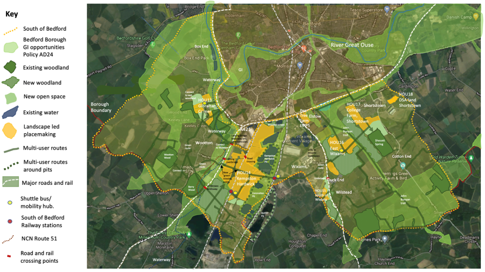
(5) 4.77 The South of Bedford Strategic policy area extends from the edge of the urban area to the borough boundary south and west of Bedford. It includes locations where strategic development is already planned or has recently taken place and new opportunities for strategic rail-based growth at the core of the Arc to deliver new jobs and homes. In addition, the area is within the Forest of Marston Vale, where there is an established agenda for landscape improvement and enhancing green infrastructure.
Overarching Vision
The South of Bedford area will be an Arc-leading place of innovation, set against the backdrop of a strong, multi-functional green infrastructure network structured around a maturing Forest of Marston Vale where distinctive healthy, walkable neighbourhoods enable people to meet their needs locally and travel actively, and where the possibilities for lower carbon living are maximised for all.
The Stewartby Hardwick rail station will open up a unique location for the creation of a new settlement set within a Forest Park of around 4,000 dwellings incorporating an innovation hub to provide high quality, local employment opportunities. The newly opened station at Wixams will support expansion of the established new settlement in proximity to further innovation-based employment provision at Pear Tree Farm.
With its good connections to Bedford, Shortstown will bring additional development opportunities including the re-use of brownfield land at the DVSA site. Also close to Bedford, development at Gibraltar Corner will support the provision of a further section of the Bedford to Milton Keynes Waterway Park which is a strategic green infrastructure priority for the Council.
Across the policy area, and against the backdrop of the Forest of Marston Vale, existing and new communities will be better linked by active travel routes, reducing car use, congestion and emissions.
(23) Policy HOU12 South of Bedford area
Within the South of Bedford policy area development will take an environment led approach and focus on enhancing natural capital by continuing to deliver the Forest of Marston Vale and enhancing the multifunctional green infrastructure network to provide the basis for distinctive place making and the setting for:
- An Arc leading new settlement incorporating a new strategic Forest Park and an innovation hub at Kempston Hardwick served by a new station on the East West Rail line at Stewartby Hardwick (Policy HOU14);
- Eastern and southern expansions to Wixams new settlement and the delivery of new station on the Midland Main Line (Policies HOU 15 and 16);
- Development at Shortstown; land at the former DVSA site (Policy HOU18) and at College Farm incorporating a mobility hub (Policy HOU17);
- Development focussed at Gibraltar Corner delivering an additional section of the Bedford Waterway Park, wet woodland and additional access to nearby green infrastructure (Policy HOU13);
- A high value business park (primarily research and development with elements of manufacturing, warehousing and distribution) at Pear Tree Farm, Elstow (Policy EMP5).
Development will be delivered in tandem with infrastructure and will require contributions to the delivery of:
- The Forest of Marston Vale (LP 2030 Policy 36S) involving a minimum of 30% tree cover to be provided across the policy area and connections to the wider network;
- The Bedford Waterway Park (Allocations and Designations Plan Policy AD27);
- Strategic transport infrastructure;
- An enhanced active travel network including an expanded Green Wheel and connections to National Cycle Network Route 51;
- Environmental regeneration including biodiversity net gain, particularly through the remediation of sites associated with the brickmaking industry;
- Healthy walking neighbourhoods;
- Multi user routes to be provided wherever possible including upgrading existing routes to bridleway status;
- Links between Stewartby Hardwick and Wixams Stations including the provision of a dedicated shuttle bus service which also connects Gibraltar Corner and East Wixams.
Development should also explore the potential for:
- Strategic solution surface water management issues;
- Community heating (LP 2030 Policy 55).
The Council will prepare a strategic place making framework to guide development across the policy area which will be adopted as Supplementary Planning Document. This will focus on matters including:
- Landscape, natural capital and green infrastructure;
- Internal and external connectivity and active and low carbon travel;
- Environmental regeneration and remediation;
- Strategic master planning and place making principles;
- Approaches to governance and stewardship of community assets;
- Infrastructure delivery in accordance with the Council's Infrastructure Delivery Plan.
The allocated residential and employment sites must be well designed and respond to the vision for the area. To ensure that quality will be created and maintained design guidance will be prepared, having regard to the strategic place making framework and where appropriate Garden City Principles, will be prepared in the form of development briefs, masterplans and design codes depending on the size of the individual sites and as specified in policies HOU13-18 and EMP5.
Elsewhere within the policy area, outside of the settlement limits defined on the policies map the adopted policies of the development plan and in particular Policy 7S will apply.
(1) 4.78 The key elements of the vision are illustrated in the strategic concept plan below
Figure 5: South of Bedford area
Land at Gibraltar Corner, Kempston Rural
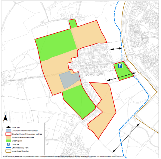
(11) 4.79 Development of land at Gibraltar Corner, Kempston Rural will contribute to the delivery of key green and blue infrastructure projects in the south of Bedford area including a section of the Bedford to Milton Keynes Waterway Park and the Forest of Marston Vale, with a particular opportunity to provide areas of wet woodland within the site. Development will help to facilitate a new school and pedestrian and cycle paths linking Wootton and Kempston. This area also contains good examples of ridge and furrow which can be incorporated into the green infrastructure of the site.
(2) 4.80 A masterplan and design code will be prepared for this site and will be adopted as SPD. It is expected that work to inform the SPD (including any technical studies that are required) will be funded by the landowner / developer.
(70) Policy HOU13 Land at Gibraltar Corner, Kempston Rural
Land at Gibraltar Corner, Kempston Rural will be developed for a mix of residential uses and open space including the delivery of strategic green infrastructure improvements. Key principles of development include:
- A masterplan and design code to be prepared and adopted as a Supplementary Planning Document prior to the submission of any planning application for the site. The preparation of the Supplementary Planning Document will be led by the Council in partnership with landowners / developers, stakeholders and the local community. This document will accord with the South of Bedford strategic framework and will be prepared in advance of the submission of a planning application and will pay particular regard to ensuring that the development is designed to preserve the setting of heritage assets;
- Provision of a mix of dwelling types and sizes;
- Submission of a Transport Assessment;
- Measures to facilitate access by bus services across the site including a shuttle bus connecting the site with Kempston Hardwick and Wixams railway stations and the provision of a mobility hub;
- Provision of a pedestrian cycleway between the site, Kempston and surrounding green infrastructure and NCN 51;
- Provision of a 2.4ha serviced site to accommodate a 2FE Primary school to include early years' provision;
- Financial contribution towards secondary school provision;
- Delivery of improvements to the green infrastructure network;
- Masterplan to ensure development is designed to preserve and, where opportunities arise, enhance the significance of heritage assets and the contribution made by setting including for:
- Grade II listed The Cottage,
- Grade II Kempston House,
- Grade II Ramsay Cottage,
- Grade II 157 Bedford Road, and
- Listed buildings in and around Keeley Green;
- Include appropriate mitigation measures where necessary for heritage assets listed under ix;
- Pre-determination archaeological evaluation for the parts of the site to be developed;
- Areas of ridge and furrow earthworks to be protected during construction;
- The developable area shall be located within Flood Zone 1;
- Contribution to the Forest of Marston Vale with a minimum of 30% tree cover to be provided on the site with appropriate public access and may include areas of wet woodland;
- Submission of a wildlife and habitat survey with appropriate mitigation and enhancements;
- Provision of land to facilitate the Bedford to Milton Keynes Waterway Park to the east of Gibraltar Corner;
- Provision of a public car parking area to provide parking for local residents and visitors, including those to the Bedford and Milton Keynes Waterway Park, Forest of Marston Vale, walking and cycling routes. The proposed car park shall be designed and located to minimise disturbance to the best preserved sections of ridge and furrow earthworks in this area;
- A site specific flood risk assessment will be needed and mitigation required for all sources of flood risk where necessary. Opportunities to reduce surface water run-off and flood risk on and off site should be identified and could consider the ability of the Waterway Park to assist with flood mitigation;
- Delivery of a low carbon and environmentally resilient development that is adaptive to and resilient to climate change;
- Early engagement with Anglian Water is required in order to identify connection to water network infrastructure.
Figure 6: Land at Gibraltar Corner
Kempston Hardwick
4.81 Land at Kempston Hardwick is allocated as a new settlement. The site is located at the heart of the South of Bedford Strategic policy area and the core of the Arc.
4.82 The site has unique locational strengths and qualities which, if properly realised and guided by appropriate design principles, will enable it to be an exemplar for low carbon living and innovation.
4.83 Provision of new rail stations giving direct to access to Oxford, Cambridge and London will make the site an ideal location for a new settlement incorporating a highly accessible innovation campus with the potential for linked academic activities, vital for facilitating a more skilled and prosperous borough. The size and scale of the Kempston Hardwick site and the new on-site rail provision provides the opportunity to create a sustainable innovation campus which is a world class destination for clean growth with high-specification business space of offices, labs, manufacturing space and affiliated distribution space within the buildings for knowledge based industries including life sciences, technology and engineering.
4.84 The site has the capacity to deliver at least 4,000 homes and the potential to deliver a distinct new place which will be structured around a site wide park which would help create the campus setting needed for high tech innovative employment uses and fulfil the requirement to provide at least 30% woodland cover and through the remediation of the lake areas to create attractive waterside environments. Within this regenerated landscape the park will have an important role in establishing the character and identity of the settlement, providing a landscaped framework to link the settlement centre at the EWR hub providing community, local employment and co-working spaces, leisure, health and cultural facilities with walking neighbourhoods providing for residents' day to day needs. The likely timing of key infrastructure provision, particularly EWR and the A421 mean that development will take place later in the plan period and deliver around 3,800 homes by 2040.
(1) 4.85 The main land uses are indicated on the plan below. The South of Bedford Framework will further develop the vision set out in paragraph 4.73 and will include guidance on the scale, character and functions of the settlement. A masterplan and design code will be prepared for this site to show how the new settlement can be delivered in accordance with the Framework and will be adopted as SPD. It is expected that work to inform the SPD (including any technical studies that are required) will be funded by the landowner / developer.
(19) Policy HOU14 Kempston Hardwick New Settlement
As identified on the Key Diagram, South of Bedford concept plan and Policies Map, land at Kempston Hardwick is allocated as a new settlement to create an Arc leading environment and landscape led, beautiful, healthy and sociable community. It will deliver at least 4,000 homes set in a new strategic Forest Park, which will also provide the landscaped setting for an innovation hub and business / science campus primarily focussed on innovation, research, development and education providing around 70ha of employment land. Development will be located in close proximity to the proposed new rail station on the East West Rail Line at Stewartby Hardwick and a new rail station on the Midland Main Line at Wixams.
The new settlement will provide all the key services and facilities to address its own needs, including health, education, retail, culture and community components, and will foster a strong local community based approach to the ownership and long-term stewardship of assets.
It will have a distinct identity based on a landscape led approach which values and enhances the natural environment and responds directly to its context. It will be developed to a high design quality achieved through a process of master planning and design coding and will be an exemplar for a new urban form and design of high tech business environment appropriate to its highly accessible location. It will incorporate a range of homes, employment, an integrated and multi-purpose green infrastructure network fully structured around a Forest Park achieving at least 30% woodland cover and lending context and character to walking neighbourhoods which will enable residents to meet the majority of their day to day needs locally and achieve access to the rail stations by active travel modes.
A strategic masterplan and design code is to be prepared by the Council in conjunction with the landowners, stakeholders and local community and adopted as a Supplementary Planning Document. This document will need to be produced ahead of the submission of any planning application and will accord with the South of Bedford strategic framework. The document will demonstrate how the new settlement will deliver the policy principles below and will include:
- A Natural Capital impact assessment and biodiversity study with appropriate mitigation and enhancements;
- A remediation and environmental regeneration strategy for the areas impacted by previous brickmaking and clay extraction activities;
- A Green Infrastructure strategy;
- A strategy for building healthy communities;
- A transport and movement strategy including infrastructure needs and access to both stations for all modes;
- A phasing strategy to ensure that the required infrastructure investment is provided in tandem with or ahead of the development it supports;
- An infrastructure delivery plan setting out the timing, funding, and provision of green, social, and physical infrastructure, including schools, community facilities and local centres in tandem with housing development;
- A strategy for sustainable long-term governance and arrangements for the stewardship of community assets;
- A site specific flood risk assessment including identifying opportunities to reduce surface water run-off and flood risk on and off site.
In order to ensure that the new settlement is brought forward in a high quality, strategic and comprehensive manner, planning permission will only be granted following the adoption of the strategic masterplan and design code.
Development must demonstrate how it has been holistically planned to accord with the objectives of the Local plan, the South of Bedford framework and the specific principles below:
GREENER
- The provision of high quality planning, design and place-making, and management of built and public realm so that the Kempston Hardwick new settlement is characterised as a distinctive Arc leading place which embraces the opportunity for compact urban form that capitalises on local assets and establishes environments that promote health, and wellbeing;
- The provision of a site wide park providing multifunctional green infrastructure delivering the 30% tree cover required as a contribution to the Marston Vale incorporating and enhancing the site's ecological and open water assets and providing well-integrated green space (formal, natural and allotments); and providing environmental net gains as well as connections and contributions to the South of Bedford green infrastructure network;
- As part of the green infrastructure network, cycle and pedestrian links to facilitate active travel within and between the neighbourhoods, business and educational areas, connectivity hubs and surrounding areas;
- An integrated surface water management solution including the integration of Sustainable Drainage Systems into the network of open spaces and lakes, to mitigate potential flood risk and enhance the environment;
- Measures to ensure resilience to climate change including measures to ensure the efficient use of energy including the exploration of the potential for district heating utilising heat from the Rookery South Energy Recovery Facility, Stewartby and sustainable drainage;
- The protection and / or enhancement of heritage and biodiversity assets within and surrounding the site, to include:
- Pre-determination archaeological evaluation for the areas of site not already evaluated,
- Archaeological mitigation ahead of development for those areas already evaluated and which contain archaeological remains,
- Masterplan to ensure development is designed to preserve and where opportunities arise enhance heritage assets and their setting, including the scheduled Moated Manor at Kempston Hardwick,
- Submission of a biodiversity report with appropriate mitigation and enhancements.
PLACEMAKING
- Place making based on a landscape led approach which draws on the heritage of the area and achieves environmental regeneration, to create an Arc leading place structured around a new Forest Park and characterised by vibrant neighbourhoods and places to work and learn, set against the backdrop of its enhanced forest setting;
- The provision of a range of house types and tenures in accordance with the most up to date assessment of housing need, including affordable housing in accordance with required levels as set out in Policy DM1(S) to meet the needs of the wider community including the ageing population;
- The provision of a mix of beautifully and imaginatively designed homes at a range of densities reflecting the context and character of different parts of the site, in particular higher densities and compact urban forms around the rail hub and settlement centre;
- The provision for a wide range of construction opportunities, offering prospects for a variety of house builders and developers including small and medium sized enterprises and including the provision of serviced plots for self-build and custom homebuilding in accordance with Policy DM5;
- The provision of serviced sites for secondary and primary schools including early years facilitates at the heart of the local neighbourhoods to serve the new development:
- Provision of serviced sites to accommodate primary schools to provide at least 8 Forms of Entry with early years provision (2x 3FE 3ha and 1 x 2FE 2.4ha),
- Provision of a serviced site within the settlement centre providing a minimum area of 10.1ha to accommodate 8FE secondary school with space for sixth form,
- Financial contribution towards secondary school provision.
- The provision of pitches for Gypsy and Travellers and plots for travelling show people to contribute to the need identified in a Gypsy and Traveller Accommodation Assessment;
- The provision of leisure and sports facilities at accessible locations in line with current standards to serve the settlement;
- The provision of multi-functional community space and healthcare facilities within local centres at the heart of walkable vibrant sociable neighbourhoods;
- Foster healthy living through access to green space as a key driver of the settlement design and opportunities for local food production, including through the provision of allotments and orchards;
- The establishment at an early stage in the development of the new settlement of appropriate and sustainable long-term governance and stewardship arrangements for community assets including green space, public realm areas and community and other relevant facilities. Such arrangements are to be funded by the development and include community representation to ensure residents have a stake in the long-term development, stewardship and management of their community;
- Design of the new settlement should incorporate appropriate mitigation measures in relation to noise sources including railway lines and the remediation of contaminated land.
ACCESSIBLE
- In accordance with the transport and movement strategy, the provision of a balanced package of measures to encourage smarter transport choices to meet the needs of the new development including the integration of technology to deliver 'on-demand' travel information and measures to reduce the number of single occupancy car trips;
- Measures should maximise the opportunities for active travel through the provision of a network of footpaths, cycle ways and bridleways to enhance permeability within the site and to the adjoining area and will include:
- connections between communities across the East West Rail Line at Stewartby Hardwick, Manor Road and one additional location between these two points to facilitate accessibility,
- new multi user routes to connect with the wider rights of way network and active travel links to Bedford,
- measures to facilitate access by bus services across the site including a shuttle bus connecting the site with Gibraltar Corner and Wixams,
- car clubs and mobility hubs,
- appropriate measures to facilitate autonomous vehicles,
- A programme of measures to facilitate accessibility and minimise and mitigate the traffic impacts on the local and strategic road network to include:
- Additional access to the B530 and the conversion of B530 / Manor Road junction to a roundabout as part of access to / from Wixams Station,
- Addition of flared approaches on the B530 approaches to the Kiln Road Roundabout,
- Realignment of Manor Road and connections to Fields Road,
- Upgrades to Broadmead Road,
- Contributions towards the provision of a footbridge to Wixams Station (west) and foot and cycle connections to Manor Road,
- The development is dependent on the delivery of transport improvements which will need to be secured before development can take place, in accordance with an agreed Infrastructure Delivery Plan.
PROSPEROUS
- The delivery of new neighbourhoods that are sociable, vibrant, and walkable (20 minutes) neighbourhoods with equality of access for all. The new settlement will provide a range of community services and facilities including health, education, retail, culture, community meeting, co-working spaces and local employment opportunities around the station and in local neighbourhoods, multifunctional open space and sports and leisure facilities;
- An innovation hub with the potential for the incorporation of academic and science park uses with elements of high tech manufacturing;
- Installation of super-fast broadband for all businesses and community facilities and also for all dwellings to support home working, at the outset of each phase of development.
Figure 7: Kempston Hardwick New Settlement
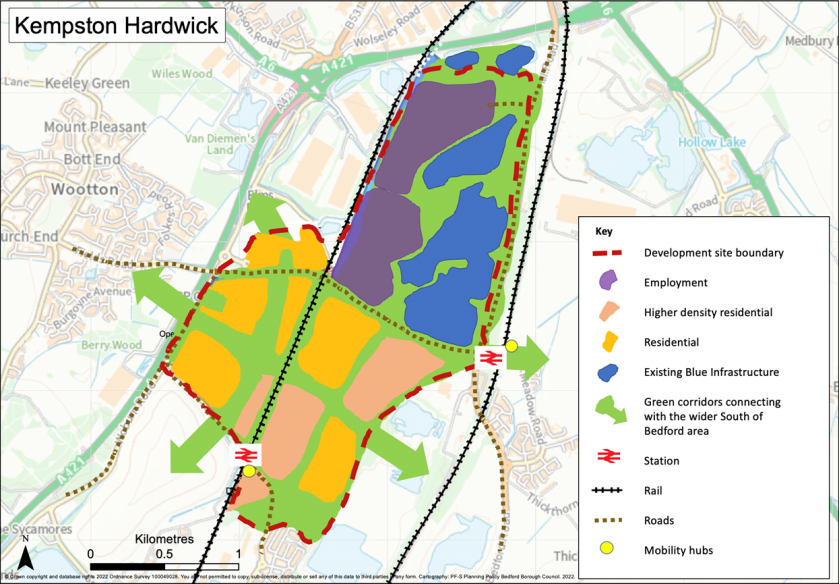
Land South of Wixams
(73) 4.86 The site adjoins the A6 and is located to the south of the existing Wixams development. Development of the site will allow for connections to Bedford and the Wixams for cyclists and pedestrians. Development will also include significant green infrastructure improvements including tree and hedgerow planting to provide publically accessible green infrastructure providing noise mitigation from the A6 and a long term buffer between Wixams and Wilstead.
(35) Policy HOU15 Land South of Wixams
Land at south of Wixams will be developed for residential uses and open space. Key principles of development include:
- Preparation by the applicant of a masterplan and design code to be completed prior to and submitted with any planning application and to accord with the South of Bedford strategic framework;
- Provision of a mix of dwelling types and sizes;
- Submission of a Transport Assessment to include:
- Improved pedestrian and cycle access from the site via the A6 and Bedford Road;
- An access strategy for vehicle access to the site and wider Wixams;
- Multi-user routes to connect to existing networks in Wixams and surrounding areas;
- A new bus stop to provide an extension to the existing bus service route in Wixams;
- Provision of a mobility hub;
- Financial contributions towards secondary school provision;
- A noise report should guide the location and design of dwellings on the site and establish any required mitigation measures.
- Contribution to the Forest of Marston Vale with a minimum of 30% tree cover to be provided on the site with appropriate public access;
- Submission of a wildlife and habitat survey with appropriate mitigation and enhancements;
- Creation of a strategic green corridor to secure a permanent green buffer between Wixams and Wilstead;
- Development should preserve and where opportunities arise enhance heritage assets and their setting, including assets located in Duck End and Wilstead;
- Pre-determination archaeological evaluation will be required;
- A site specific flood risk assessment will be needed and mitigation required for all sources of flood risk where necessary; Opportunities to reduce surface water run-off and flood risk on and off site should be identified;
- Delivery of a low carbon and environmentally resilient development that is adaptive to and resilient to climate change.
Land East of Wixams
(12) 4.87 The site is located to the east of the A6 and the existing Wixams development. The proposals will complement the existing development at Wixams and provide additional facilities and infrastructure including schools and an employment hub to cater for a range of flexible employment uses. The site also has the potential to create pedestrian and cycle connections to Shortstown and the Wixams. The additional development and new population will allow for an extension of the public transport service to allow for more sustainable travel to Bedford. The Meteorological Research Unit at Cardington located to the east of the site will be an important consideration in the masterplanning of the site due to the potential impact of new development on its current operations.
(61) Policy HOU16 Land at East Wixams
Land at East of Wixams will be developed for residential, community and open space uses.
Key principles of development include:
- Preparation by the applicant of a masterplan and design code to be completed prior to and submitted with any planning application and to accord with the South of Bedford strategic framework. The masterplan and design code should be prepared in consultation with the Met Office to ensure that the limitations created by the proximity of the Meteorological Research Unit at Cardington Airfield are fully considered;
- Provision of a mix of dwelling types and sizes;
- The development is dependent on the delivery of transport improvements which will need to be secured before development can take place in accordance with an agreed Infrastructure Delivery Plan;
- Provision of a full Transport Assessment to be submitted with any planning application;
- Traffic mitigation for the existing roundabouts off A6 to accommodate the new development;
- Extension of the bus service from the existing Wixams bus network including the provision of new bus stops to service the new development, measures to facilitate a shuttle bus connecting the site with Gibraltar Corner and Kempston Hardwick and a mobility hub;
- Provision or upgrading of existing pedestrian and cycle links to bridleway status to allow active travel to Shortstown and Wixams including the crossing of the A6;
- Provision of two 2.4ha serviced sites to accommodate two form entry primary schools to include early years' provision;
- Provision of an 11ha serviced site to accommodate a nine form entry secondary school to include sixth form provision;
- Financial contribution towards secondary school provision;
- Contribution to the Forest of Marston Vale with a minimum of 30% tree cover to be provided on the site with appropriate pubic access;
- Development should preserve and, where opportunities arise, enhance heritage assets and their setting, including assets located in Duck End, with appropriate mitigation measures adopted along the southern boundary of the site;
- Pre-determination archaeological evaluation will be required;
- A site specific flood risk assessment will be needed and mitigation required for all sources of flood risk where necessary;
- Delivery of low carbon and environmentally resilient development that is adaptive to and resilient to climate change.
Figure 8: Land South and East of Wixams
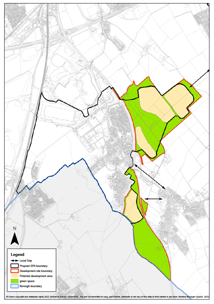
College Farm, Shortstown
(5) 4.88 Land at College Farm, Shortstown offers the opportunity for sustainable residential development which will also contribute to the wider south of Bedford area allowing sustainable transport and green infrastructure linkages with Wixams to the west and beyond, including to the Wixams and Stewartby Hardwick railway stations. The proposals will complement the existing development at Shortstown and provide additional facilities including a new Primary School. The Meteorological Research Unit at Cardington, located to the east of the site will be an important consideration in the master planning of the site due to the potential impact of development on its current operations.
(25) Policy HOU17 Land at College Farm, Shortstown
Land at College Farm, Shortstown will be developed for residential uses and open space.
Key principles of development to be addressed include:
- Preparation by the applicant of a masterplan and design code to be completed prior to and submitted with any planning application and to accord with the South of Bedford strategic framework. The masterplan and design code should be prepared in consultation with the Met Office to ensure that the limitations created by the proximity of the Meteorological Research Unit at Cardington Airfield are fully considered;
- Provision of a mix of dwelling types and sizes;
- The development is dependent on the delivery of transport improvements which will need to be secured before development can take place in accordance with an agreed Infrastructure Delivery Plan;
- Submission of a Transport Assessment to include measures to mitigate impact of the development on the local and strategic route network and to maximise opportunities for sustainable travel;
- Provision of a mobility hub;
- Provision of a 2.4ha serviced site to accommodate a 2FE Primary school to include early years' provision;
- Financial contribution towards secondary school provision;
- Buffer planting and landscaping to assimilate the development into the surrounding landscape;
- Contribution to the Forest of Marston Vale with a minimum of 30% tree cover to be provided on the site with appropriate public access;
- Identification of opportunities to enhance green infrastructure including connections to existing networks;
- Provision of public open space;
- Development should be designed to preserve and, where opportunities arise, enhance heritage assets and their setting, including:
- Grade II* Cardington Sheds 1 and 2
- Listed buildings in Harrowden
- Pre-determination archaeological evaluation across part of site not already subject to evaluation;
- A site specific flood risk assessment will be needed and mitigation required for all sources of flood risk where necessary; Opportunities to reduce surface water run-off and flood risk on and off site should be identified. New development will be steered to areas of lowest flood risk;
- Submission of a wildlife and habitat survey with appropriate mitigation and enhancements;
- Delivery of a low carbon and environmentally resilient development that is adaptive to and resilient to climate change.
Figure 9: College Farm and DVSA sites, Shortstown
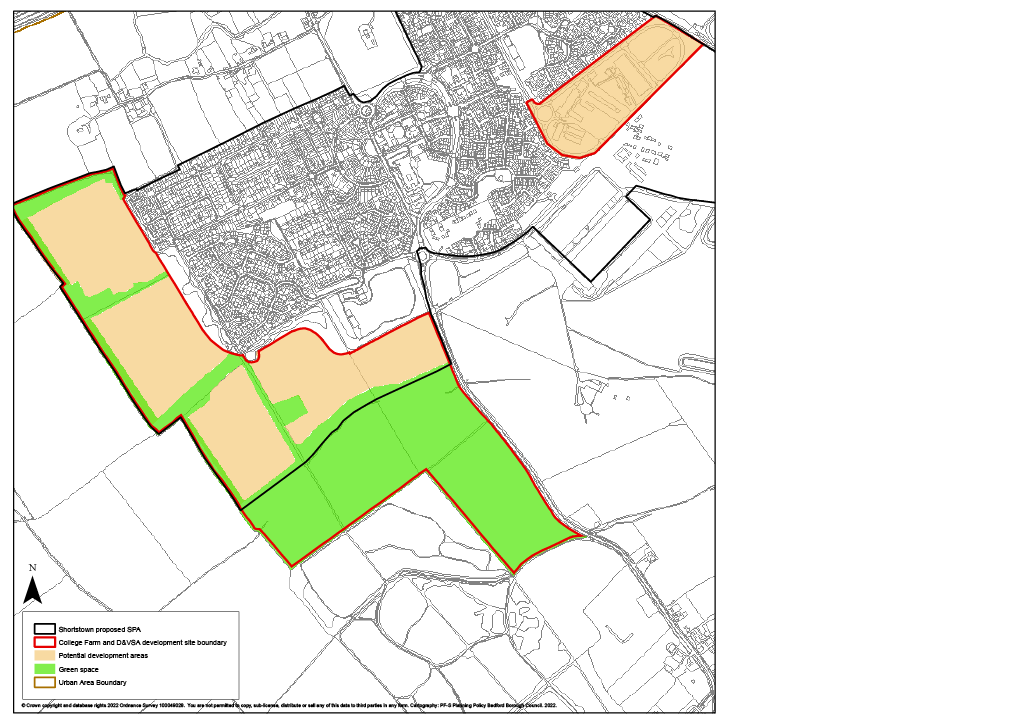
Land at Former Driver and Vehicle Standards Agency (DVSA) Site, Shortstown
(1) 4.89 Following the closure of the DVSA at Shortstown, the site is now available for redevelopment. The site is surrounded by residential development to the north and west and is suitable for residential use. The site is however adjacent to the Grade II* listed Cardington Airship Sheds and this will need to be taken into consideration.
(12) Policy HOU18 Land at Former DVSA Site, Shortstown
Land at the former DVSA site, Shortstown will be developed for residential use. Key principles of development include:
- Preparation by the applicant of a masterplan and design code to be completed prior to and submitted with any planning application and to accord with the South of Bedford strategic framework;
- Provision of a mix of dwelling types and sizes;
- Submission of a Transport Assessment to include measures to mitigate impact of the development on the local and strategic route network and to maximise opportunities for sustainable travel;
- Provision of a mobility hub;
- Provision of a footway and cycleway to link in with the existing network and adjacent sites;
- Development should preserve and, where opportunities arise, enhance heritage assets and their setting, including:
- Grade II* Cardington Sheds 1 and 2
- Grade II Cardington Railway Station
- Cardington Conservation Area
- Pre-determination archaeological evaluation will be required;
- Financial contributions to secondary school provision;
- Contaminated land assessment to be submitted with the planning application;
- Habitat survey required as the site is identified as high risk for Great Crested Newts;
- Contribution to the Forest of Marston Vale with a minimum of 30% tree cover to be provided on the site;
- A site specific flood risk assessment will be needed and mitigation required for all sources of flood risk where necessary; Opportunities to reduce surface water run-off and flood risk on and off site should be identified;
- Delivery of a low carbon and environmentally resilient development that is adaptive to and resilient to climate change;
- Early engagement with Anglian Water is required in order to identify connection to water network infrastructure.
Land at Pear Tree Farm, Elstow
4.90 The site at Pear Tree Farm, Elstow is a strategically located site at the junction of the A421 and A6 roads with pedestrian and cycle connections to Wixams and EWR stations. The design and location of buildings within this site will be important in order to minimise landscape impact and avoid coalescence with Wixams and Elstow. A key design consideration will be to ensure that sufficient separation is provided between the proposed employment development and Elstow village. For this reason, land between the development allocation and the village is identified on the Policies Map as Urban Open Space. This complies with criterion (vi) of Policy AD43 Urban Open Space. Proposals for development within the Urban Open Space will be determined in accordance with Policy AD43.
(1) 4.91 Significant green infrastructure benefits outside the allocated site will be delivered in association with the development, such as pedestrian and cycle links, recognising the objectives of the Bedford Green Wheel and Forest of Marston Vale projects.
(30) Policy EMP5 Land at Pear Tree Farm, Elstow
Land at Pear Tree Farm will be developed for a science park (primarily research and development with elements of manufacturing, warehousing and related distribution). Key principles of development include:
- Preparation by the applicant of a masterplan and design code to be completed prior to and submitted with any planning application and to accord with the South of Bedford strategic framework. The masterplan and design code will ensure that the site is developed as a high value business park providing primarily research and development space in a landscaped setting;
- 20.4 hectares employment site;
- Design to respect local landscape priorities, with particular regard to views of Elstow Abbey and ensuring separation from Elstow village;
- Retention of open land to maintain separation between the development and Elstow Village;
- Contribution to the Forest of Marston Vale with a minimum of 30% tree cover to be provided on the site;
- Delivery of Forest of Marston Vale planting as a buffer along the boundary with the A421;
- Provision of a green corridor incorporating a pedestrian and cycle route south of the A421 west / east from the A6 to Bumpy Lane and the A600;
- A site specific flood risk assessment will be needed and mitigation required for all sources of flood risk where necessary; Opportunities to reduce surface water run-off and flood risk on and off site should be identified and implemented;
- Development should preserve and where opportunities arise enhance heritage assets and their setting;
- Pre-determination archaeological evaluation will be required;
- Submission of a wildlife and habitat survey with appropriate mitigation and enhancements;
- Submission of a Transport Assessment to include measures to mitigate impact of the development on the local and strategic route network and to maximise opportunities for sustainable travel;
- Provision of a pedestrian / cycle bridge across the A421 between the site and Abbey Field or contribution towards pedestrian and cycle links required on the west side of the A6 from Wilstead Road roundabout and across the A421 / A6 junction to Bedford and Wixams;
- Delivery of a low carbon and environmentally resilient development that is adaptive to and resilient to climate change.
Figure 10: Land at Pear tree Farm, Elstow
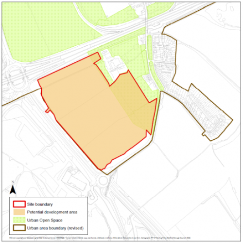
Little Barford
(1) 4.92 Land at Little Barford is allocated as a new settlement, contributing to the delivery of the Bedford Local Plan's spatial growth strategy. The development of Little Barford will make a key contribution towards the additional homes required to be delivered across the borough by 2040, delivering at least 4,000 new homes overall, of which an estimated 3,800 will be within the current plan period.
(1) 4.93 The new settlement is located to the north east of Bedford, close to the neighbouring town of St Neots. The East Coast Main Line railway line runs north to south through the site and the proposed A428 Black Cat to Caxton Gibbet relief road runs through the site providing an opportunity for a strategic road junction. In addition, EWR will be crossing in the vicinity, possibly through the site, and will include a station offering the opportunity of a highly sustainable site accessible by rail and the strategic road network. In addition to the allocation site there is further land within the same ownership which is identified as a contingency area, should land be required to facilitate the EWR route and / or station within the site. The allocation site and contingency land are illustrated by the plan below.
4.94 The proximity of the site to the existing Little Barford employment area to the north offers the opportunity to locate new employment development by way of extension and / or in other areas of the site to benefit the local economy and provide further employment opportunities.
4.95 The site has unique locational strengths and qualities which, if properly realised and guided by appropriate design principles, will enable it to be an exemplar for low carbon living and innovation.
4.96 The potential to designate a conservation area at Little Barford is being investigated by the Local Planning Authority.
(24) Policy HOU19 Little Barford New Settlement
As identified on the Key Diagram and Policies Map, land at Little Barford is allocated as a new settlement to create a landscape led beautiful, healthy and sociable community located in close proximity to the proposal for a new station on the East West Rail line delivering at least 4,000 new homes and in the region of 4 hectares employment. It will provide all the key services and facilities to address its own needs, including health, education, retail, culture and community components, and will foster a strong local community based approach to the ownership and long-term stewardship of assets.
The new settlement will have a distinct identity based on a landscape led approach which values and enhances the natural environment and responds directly to its context. The settlement will be developed to a high design quality achieved through a process of master planning and design coding and will incorporate a range of homes, employment, an integrated and multi-purpose green infrastructure network lending context and character to walking neighbourhoods which will enable residents to meet the majority of their day to day needs locally and achieve access to the new East West Rail station by active travel modes.
A strategic masterplan and design code is to be prepared by the Council in conjunction with the landowners, stakeholders and local community and adopted as a Supplementary Planning Document. This document will need to be produced ahead of the submission of any planning application and will demonstrate how the new settlement will deliver the policy principles below and will include:
- A Natural Capital impact assessment and biodiversity study with appropriate mitigation and enhancements;
- A Green Infrastructure strategy;
- A transport and movement strategy including infrastructure needs and the relationship to East West Rail;
- A phasing strategy to ensure that infrastructure investment is provided in tandem with or ahead of the development it supports;
- An infrastructure delivery plan setting out the timing, funding, and provision of green, social, and physical infrastructure, including schools, community facilities and local centres in tandem with housing development;
- Character assessment and master planning;
- Design coding;
- A strategy for sustainable long-term governance and arrangements for the stewardship of community assets;
- A detailed assessment of the mineral resource within the Mineral Safeguarding Area to examine quantity, quality and feasibility of extraction;
- A site specific flood risk assessment including identifying opportunities to reduce surface water run-off and flood risk on and off site;
- A detailed heritage impact assessment.
In order to ensure that the new settlement is brought forward in a high quality, strategic and comprehensive manner, planning permission will only be granted following the adoption of the strategic masterplan and design code. Development must demonstrate how it has been holistically planned to accord with the objectives of the Local plan and the specific principles below:
GREENER
- The provision of high quality planning, design and place-making, and management of built and public realm so that the Little Barford new settlement is characterised as a distinctive place that capitalises on local assets and establishes environments that promote health, and wellbeing;
- The provision of a multifunctional green infrastructure which: retains, enhances, connects, and increases accessibility to the green infrastructure network including the River Great Ouse and on site woodland areas; provides well-integrated green space (formal, natural and allotments); and provides environmental net gains;
- As part of the green infrastructure network, cycle and pedestrian links to facilitate active travel within the neighbourhoods and surrounding areas;
- Integration of Sustainable Drainage Systems into the network of open spaces, to mitigate potential flood risk, and measures to ensure resilience to climate change including measures to ensure the efficient use of energy and water in accordance with Policy 93;
- The Council will consider whether any areas of the Little Barford settlement merit designation as a Conservation Area. In the event of its designation, development must preserve and where opportunities arise, enhance its special interest.
- The protection and / or enhancement of heritage and biodiversity assets within and surrounding the site, to include:
- Any new development should contribute positively to local character and distinctiveness and enhance or better reveal the significance of any designated heritage assets affected,
- Pre-determination archaeological evaluation in all areas which will potentially be impacted by development and where the nature and significance of the archaeological resource does not necessitate preservation in situ,
- Development should also seek to sympathetically reuse built heritage and retain those non-designated heritage assets of archaeological interest in situ, including above ground settlement and associated earthworks, which make a positive contribution to the appearance, understanding, appreciation and interpretation of the historic settlement,
- Submission of a biodiversity report with appropriate mitigation and enhancements.
PLACEMAKING
- Place making based on a landscape led approach to creating a vibrant place which is sensitive to local character and creates distinctive neighbourhoods;
- The provision of a range of house types and tenures in accordance with the most up to date assessment of housing need, including affordable housing in accordance with required levels as set out in Policy DM1(S) to meet the needs of the wider community including the ageing population;
- The provision of a mix of beautifully and imaginatively designed homes at a range of densities reflecting the context and character of different parts of the site, in particular lower densities in accordance with the historic character of the western side of the site and higher densities in areas with higher accessibility to the East West Rail station and local centres;
- The provision for a wide range of construction opportunities, offering prospects for a variety of house builders and developers including small and medium sized enterprises and including the provision of serviced plots for self-build and custom homebuilding in accordance with Policy DM5;
- The provision of serviced sites for secondary and primary schools including early years facilitates at the heart of the local neighbourhoods to serve the new development, (2 x 5.5ha 4FE primary and 1 x 10.1ha 8FE secondary schools); Due to the lack of capacity in existing schools, additional capacity will be required to be open prior to the occupation of the first dwelling. Financial contribution towards secondary school provision;
- The provision of pitches for Gypsy and Travellers and plots for travelling show people where need is identified in a Gypsy and Traveller Accommodation Assessment;
- The provision of leisure and sports facilities at accessible locations in line with current standards to serve the settlement;
- The provision of multi-functional community space and healthcare facilities within local centres at the heart of walkable vibrant sociable neighbourhoods;
- The fostering of healthy living through access to green space as a key driver of the settlement design and opportunities for local food production;
- The establishment at an early stage in the development of the new settlement of appropriate and sustainable long-term governance and stewardship arrangements for community assets including green space, public realm areas and community and other relevant facilities. Such arrangements are to be funded by the development and include community representation to ensure residents have a stake in the long-term development, stewardship and management of their community;
- Layout and design of the new settlement should incorporate appropriate mitigation measures in relation to high pressure gas pipelines, overhead power lines and noise sources including railway lines.
ACCESSIBLE
- In accordance with the transport and movement strategy, the provision of a balanced package of measures to encourage smarter transport choices to meet the needs of the new development including the integration of technology to deliver 'on-demand' travel information and measures to reduce the number of single occupancy car trips;
- Measures should maximise the opportunities for active travel through the provision of a network of footpaths, cycle ways and bridleways to enhance permeability within the site and to the adjoining area and will include:
- connections between communities across the East Coast Main Line at a minimum of two locations,
- new footway and cycle routes including the integration of National Cycle Network (NCN) route 12 through the site,
- links to the East West Rail station including the provision of a dedicated shuttle bus service from the site,
- measures to facilitate access by bus services across the site,
- provision of charging points for electric vehicles,
- car clubs and mobility hubs,
- appropriate measures to facilitate autonomous vehicles,
- A programme of measures to facilitate accessibility and minimise and mitigate the traffic impacts on the local and strategic road network to include:
- widening of Barford Road and any necessary new junctions,
- widening of the existing footway and conversion to a cycle / pedestrian route on Barford Road up to the A428 roundabout,
- provision of a multi-user route alongside River Great Ouse and potential to cross the river,
- The development is dependent on the delivery of transport improvements which will need to be secured before development can take place in accordance with an agreed Infrastructure Delivery Plan.
PROSPEROUS
- The delivery of new neighbourhoods that are sociable, vibrant, and walkable (20 minutes) neighbourhoods with equality of access for all. The new settlement will provide a range of community services and facilities including health, education, retail, culture, community meeting spaces, multifunctional open space and sports and leisure facilities;
- Approximately 3.6 ha of industrial and warehousing employment land, to be located adjacent to and act as an expansion of the existing Little Barford employment area;
- Installation of super-fast broadband for all businesses and community facilities and also for all dwellings to support home working, at the outset of each phase of development.
Figure 11: Little Barford New Settlement[15]
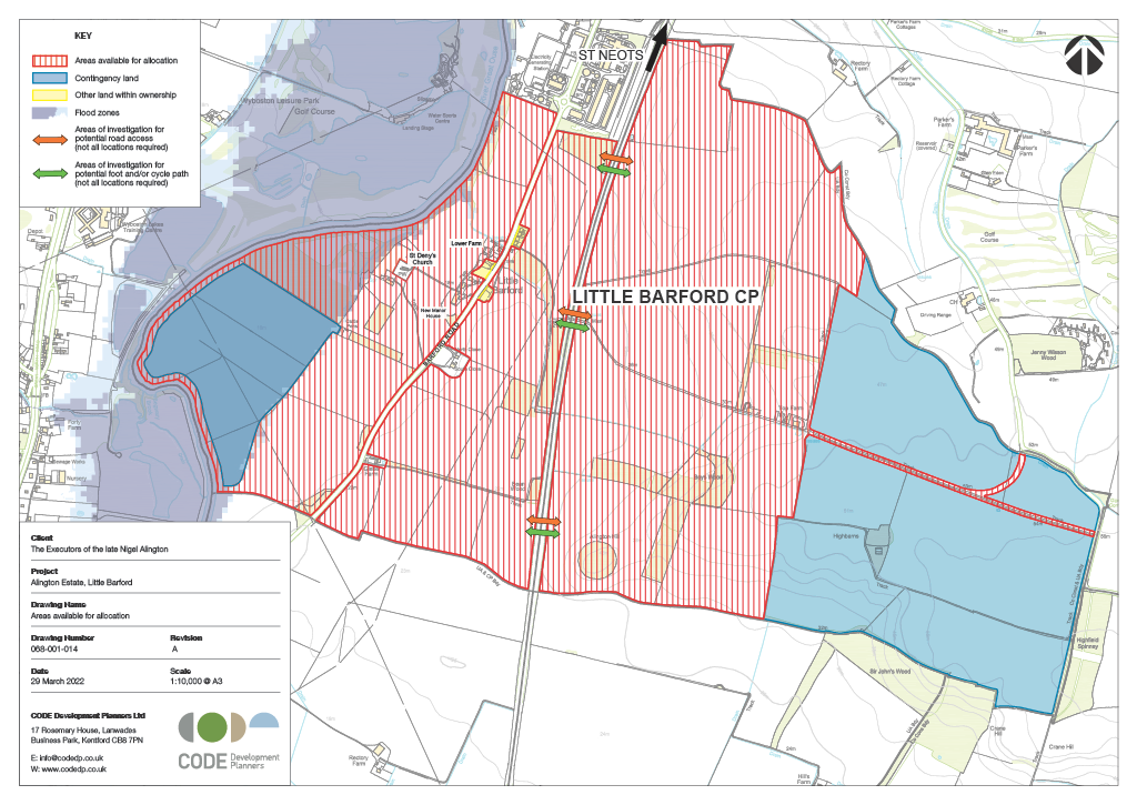
Other employment sites
Land at Water End and St Neots Road
4.97 The site at Water End / St Neots Road lies adjacent to a junction on the A421 east of Bedford and has excellent links to the strategic road network. Particular attention should be paid to the impact of additional traffic movements on the junction. The site provides the opportunity to develop a modern research campus-style development, primarily for research and development with elements of manufacturing, warehousing and distribution all within a landscaped setting. Such a campus-like environment is suitable for higher-end business occupiers to enable them to attract and retain skilled staff. In developing the site, it will be important to ensure that there is adequate separation from the existing residential buildings at Green End.
(118) Policy EMP6 Business Park, Land at Water End and St Neots Road
Land at Water End and St Neots Road will be developed for a campus-style development (primarily research and development with elements of manufacturing, warehousing and distribution). Key principles of development include:
- A research campus of approximately 30 hectares in total on two sites at Water End and St Neots Road;
- Preparation by the applicant of a masterplan and design code to be completed prior to and submitted with any planning application. The master plan and design code will ensure that the site is developed as a high value business park providing primarily research and development space in a landscaped setting;
- Design to respect local landscape priorities, ensuring separation from Renhold, Green End village and the need for sensitive external lighting;
- Provision of high quality landmark / gateway buildings at A421 junction in a landscaped environment;
- Pre-determination archaeological evaluation will be required;
- Development should be designed where possible to preserve and where opportunities arise, enhance the significance of heritage assets and the contribution made by setting, including for:
- Scheduled monument of Howbury ringwork and Medieval Trackway,
- Grade II listed Great Dairy Farmhouse,
- Grade II listed Hill Farmhouse,
- Grade II listed 52 Green End,
- Grade II listed Howbury Hall and associated heritage assets,
- Include appropriate mitigation measures where necessary for heritage assets listed under vi;
- Delivery of a low carbon and environmentally resilient development that is adaptive to and resilient to climate change;
- Submission of a Transport Assessment to include:
- Improvements to the A421 junction roundabouts,
- Measures to ensure sustainable travel to / from the development,
- Provision of a mobility hub;
- Submission of a wildlife and habitat survey with appropriate mitigation and enhancements;
- A site specific flood risk assessment will be needed and mitigation required for all sources of flood risk where necessary. Opportunities to reduce surface water run-off by on and off site should be identified;
- Early engagement with Anglian Water is required in order to identify connection to water network infrastructure.
Land at College Farm
4.98 Land at College Farm will be accessed from a new Black Cat roundabout at the junction of the A421 and A1. The junction is being redesigned to accommodate the A421 extension eastwards to Caxton Gibbet. Given the site's excellent links to the strategic road network it is suitable for a variety of roadside service facilities as well as employment uses.
(7) Policy EMP7 Land at College Farm, Black Cat roundabout
Land at College Farm, Black Cat roundabout will be developed for roadside services, industrial, warehousing and distribution uses. Key principles of development include:
- Roadside service facilities including, service station, hotel, lorry park and associated roadside service facilities;
- 3.0 hectares employment site;
- A site specific flood risk assessment will be needed and mitigation required for all sources of flood risk where necessary;
- A Transport Assessment will be required to identify the impact of traffic on the highway and necessary mitigations including measures to ensure sustainable travel to / from the development;
- Archaeological excavation of areas within the proposal site not previously investigated / excavated ahead of quarrying or in connection with the A428 scheme;
- Submission of a wildlife and habitat survey with appropriate mitigation and enhancements;
- Design should consider the need for sensitive external lighting;
- Delivery of a low carbon and environmentally resilient development that is adaptive to and resilient to climate change.
Land to South West of Black Cat Roundabout
(3) 4.99 To the south-west of the Black Cat roundabout the site of the Roxton Garden Centre is allocated for employment. Its excellent links to the strategic road network make it particularly suited to warehousing and distribution uses. In developing the site, it will be important to ensure that there is adequate separation from the existing residential buildings at Roxton.
(10) Policy EMP8 Land at Roxton, south west of the Black Cat roundabout
Land at Roxton, south west of the Black Cat roundabout will be developed for warehousing and distribution uses. Key principles of development include:
- 17.0 hectares employment site;
- Preparation by the applicant of a masterplan and design code to be completed prior to and submitted with any planning application. The masterplan and design code will ensure that the site is developed in a landscaped setting that minimises its impact on nearby residential properties;
- Design to respect local landscape priorities, ensuring separation from nearby residential properties in Roxton;
- A site specific flood risk assessment will be needed and mitigation required for all sources of flood risk where necessary; Opportunities to reduce surface water run-off and flood risk on and off site should be identified;
- Pre-determination archaeological evaluation will be required;
- Development should designed to preserve and where opportunities arise enhance the significance of heritage assets and the contribution made by their setting including for:
- Scheduled monument of Tempsford Bridge,
- Roxton Conservation Area and assets within,
- Include appropriate mitigation measures where necessary for heritage assets listed under vi;
- Submission of a wildlife and habitat survey with appropriate mitigation and enhancements;
- A Transport Assessment will be required to identify the impact of traffic on the highway and necessary mitigations including measures to ensure sustainable travel to / from the development;
- The development is dependent on the delivery of transport improvements which will need to be secured before development can take place in accordance with an agreed Infrastructure Delivery Plan;
- Design should consider the need for sensitive external lighting;
- Delivery of a low carbon and environmentally resilient development that is adaptive to and resilient to climate change.
(5) 4.100 The Local Plan 2040 Key Diagram is below.
Figure 12: Key Diagram
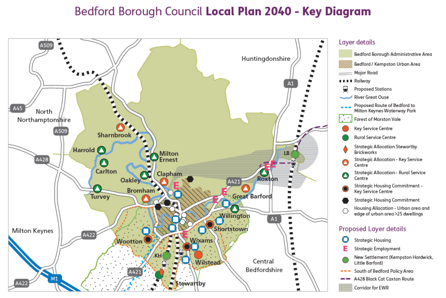
[15] (Figure 11 was replaced on 29/4/22 following approval of the local plan by Executive on 27/4/22. The main change being the references to 'Contingency land' and 'Other land within ownership')